You are here: Home > Network List > TA - USArray Transportable Network (new EarthScope stations) Stations List
> Station F20K Avaraart Lake, AK, USA > Earthquake Result Viewer
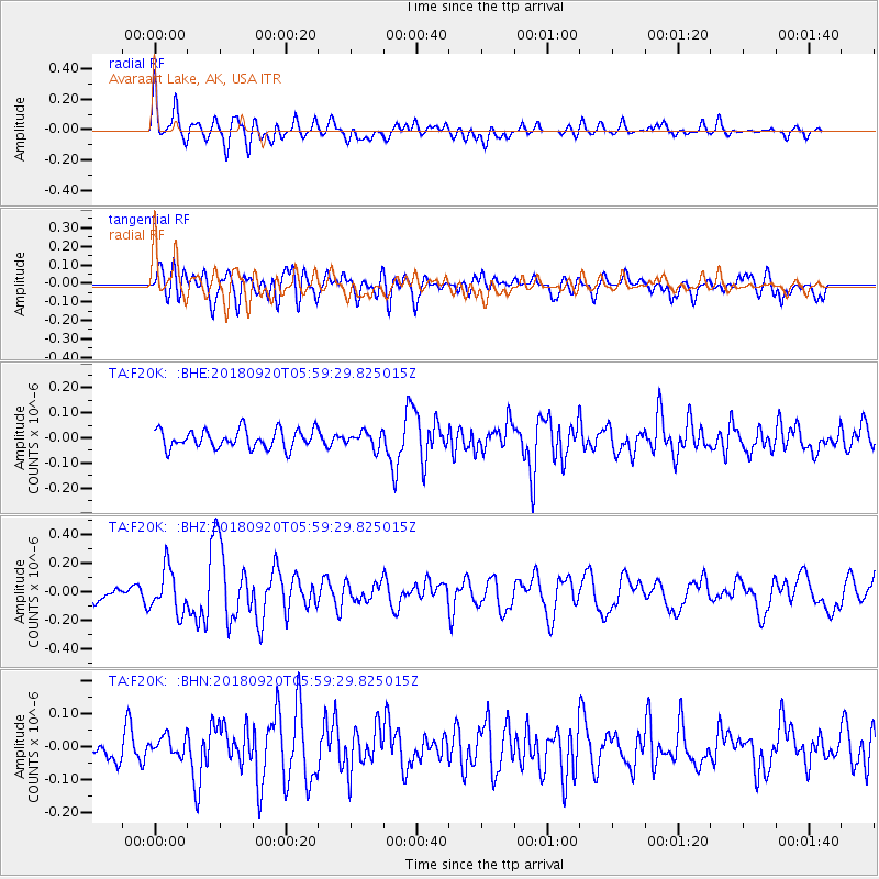
F20K Avaraart Lake, AK, USA - Earthquake Result Viewer
*The percent match for this event was below the threshold and hence no stack was calculated.
| Earthquake location: |
Solomon Islands |
| Earthquake latitude/longitude: |
-9.0/158.3 |
| Earthquake time(UTC): |
2018/09/20 (263) 05:47:37 GMT |
| Earthquake Depth: |
10 km |
| Earthquake Magnitude: |
5.5 mb |
| Earthquake Catalog/Contributor: |
NEIC PDE/us |
|
| Network: |
TA USArray Transportable Network (new EarthScope stations) |
| Station: |
F20K Avaraart Lake, AK, USA |
| Lat/Lon: |
67.05 N/155.73 W |
| Elevation: |
136 m |
|
| Distance: |
82.7 deg |
| Az: |
16.511 deg |
| Baz: |
225.715 deg |
| Ray Param: |
$rayparam |
*The percent match for this event was below the threshold and hence was not used in the summary stack. |
|
| Radial Match: |
66.968544 % |
| Radial Bump: |
400 |
| Transverse Match: |
62.371273 % |
| Transverse Bump: |
400 |
| SOD ConfigId: |
13570011 |
| Insert Time: |
2019-05-01 07:06:07.988 +0000 |
| GWidth: |
2.5 |
| Max Bumps: |
400 |
| Tol: |
0.001 |
|
Signal To Noise
| Channel | StoN | STA | LTA |
| TA:F20K: :BHZ:20180920T05:59:29.825015Z | 3.466769 | 1.5324926E-7 | 4.4205212E-8 |
| TA:F20K: :BHN:20180920T05:59:29.825015Z | 0.7592653 | 2.9937915E-8 | 3.943011E-8 |
| TA:F20K: :BHE:20180920T05:59:29.825015Z | 0.8301076 | 3.0797434E-8 | 3.710053E-8 |
| Arrivals |
| Ps | |
| PpPs | |
| PsPs/PpSs | |


