You are here: Home > Network List > TA - USArray Transportable Network (new EarthScope stations) Stations List
> Station G16K Koyuk River, AK, USA > Earthquake Result Viewer
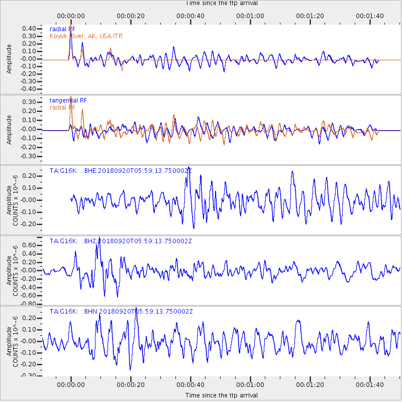
G16K Koyuk River, AK, USA - Earthquake Result Viewer
*The percent match for this event was below the threshold and hence no stack was calculated.
| Earthquake location: |
Solomon Islands |
| Earthquake latitude/longitude: |
-9.0/158.3 |
| Earthquake time(UTC): |
2018/09/20 (263) 05:47:37 GMT |
| Earthquake Depth: |
10 km |
| Earthquake Magnitude: |
5.5 mb |
| Earthquake Catalog/Contributor: |
NEIC PDE/us |
|
| Network: |
TA USArray Transportable Network (new EarthScope stations) |
| Station: |
G16K Koyuk River, AK, USA |
| Lat/Lon: |
65.39 N/162.35 W |
| Elevation: |
169 m |
|
| Distance: |
79.7 deg |
| Az: |
15.648 deg |
| Baz: |
219.521 deg |
| Ray Param: |
$rayparam |
*The percent match for this event was below the threshold and hence was not used in the summary stack. |
|
| Radial Match: |
68.47266 % |
| Radial Bump: |
400 |
| Transverse Match: |
66.55765 % |
| Transverse Bump: |
400 |
| SOD ConfigId: |
13570011 |
| Insert Time: |
2019-05-01 07:06:14.455 +0000 |
| GWidth: |
2.5 |
| Max Bumps: |
400 |
| Tol: |
0.001 |
|
Signal To Noise
| Channel | StoN | STA | LTA |
| TA:G16K: :BHZ:20180920T05:59:13.750002Z | 2.9706829 | 1.952657E-7 | 6.5730916E-8 |
| TA:G16K: :BHN:20180920T05:59:13.750002Z | 1.6747308 | 6.801697E-8 | 4.0613678E-8 |
| TA:G16K: :BHE:20180920T05:59:13.750002Z | 1.2493842 | 5.0912636E-8 | 4.0750184E-8 |
| Arrivals |
| Ps | |
| PpPs | |
| PsPs/PpSs | |


