You are here: Home > Network List > US - United States National Seismic Network Stations List
> Station EGMT Eagleton, Montana, USA > Earthquake Result Viewer
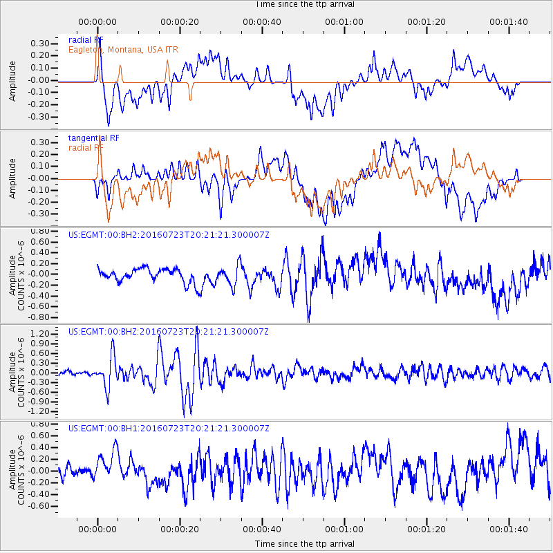
EGMT Eagleton, Montana, USA - Earthquake Result Viewer
*The percent match for this event was below the threshold and hence no stack was calculated.
| Earthquake location: |
Tonga Islands |
| Earthquake latitude/longitude: |
-15.1/-173.6 |
| Earthquake time(UTC): |
2016/07/23 (205) 20:09:19 GMT |
| Earthquake Depth: |
10 km |
| Earthquake Magnitude: |
5.7 MB |
| Earthquake Catalog/Contributor: |
NEIC PDE/NEIC COMCAT |
|
| Network: |
US United States National Seismic Network |
| Station: |
EGMT Eagleton, Montana, USA |
| Lat/Lon: |
48.02 N/109.75 W |
| Elevation: |
1055 m |
|
| Distance: |
84.6 deg |
| Az: |
37.254 deg |
| Baz: |
240.581 deg |
| Ray Param: |
$rayparam |
*The percent match for this event was below the threshold and hence was not used in the summary stack. |
|
| Radial Match: |
67.11239 % |
| Radial Bump: |
400 |
| Transverse Match: |
68.73392 % |
| Transverse Bump: |
400 |
| SOD ConfigId: |
1634031 |
| Insert Time: |
2016-08-06 20:31:26.291 +0000 |
| GWidth: |
2.5 |
| Max Bumps: |
400 |
| Tol: |
0.001 |
|
Signal To Noise
| Channel | StoN | STA | LTA |
| US:EGMT:00:BHZ:20160723T20:21:21.300007Z | 7.1229815 | 4.930883E-7 | 6.922498E-8 |
| US:EGMT:00:BH1:20160723T20:21:21.300007Z | 3.2507718 | 3.0158597E-7 | 9.2773654E-8 |
| US:EGMT:00:BH2:20160723T20:21:21.300007Z | 1.4686676 | 1.8824281E-7 | 1.281725E-7 |
| Arrivals |
| Ps | |
| PpPs | |
| PsPs/PpSs | |


