You are here: Home > Network List > AV - Alaska Volcano Observatory Stations List
> Station PLBL Mt. Peulik Volcano, Alaska > Earthquake Result Viewer
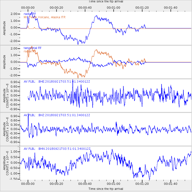
PLBL Mt. Peulik Volcano, Alaska - Earthquake Result Viewer
*The percent match for this event was below the threshold and hence no stack was calculated.
| Earthquake location: |
Fiji Islands Region |
| Earthquake latitude/longitude: |
-17.9/-179.9 |
| Earthquake time(UTC): |
2018/09/21 (264) 03:40:40 GMT |
| Earthquake Depth: |
653 km |
| Earthquake Magnitude: |
5.9 Mww |
| Earthquake Catalog/Contributor: |
NEIC PDE/us |
|
| Network: |
AV Alaska Volcano Observatory |
| Station: |
PLBL Mt. Peulik Volcano, Alaska |
| Lat/Lon: |
57.70 N/156.82 W |
| Elevation: |
461 m |
|
| Distance: |
77.7 deg |
| Az: |
12.464 deg |
| Baz: |
202.502 deg |
| Ray Param: |
$rayparam |
*The percent match for this event was below the threshold and hence was not used in the summary stack. |
|
| Radial Match: |
62.78277 % |
| Radial Bump: |
400 |
| Transverse Match: |
59.54167 % |
| Transverse Bump: |
400 |
| SOD ConfigId: |
13570011 |
| Insert Time: |
2019-05-01 07:11:57.846 +0000 |
| GWidth: |
2.5 |
| Max Bumps: |
400 |
| Tol: |
0.001 |
|
Signal To Noise
| Channel | StoN | STA | LTA |
| AV:PLBL: :BHZ:20180921T03:51:01.340012Z | 3.2851582 | 3.8719503E-7 | 1.17861916E-7 |
| AV:PLBL: :BHN:20180921T03:51:01.340012Z | 1.535845 | 3.770351E-7 | 2.4549033E-7 |
| AV:PLBL: :BHE:20180921T03:51:01.340012Z | 2.099547 | 3.99228E-7 | 1.901496E-7 |
| Arrivals |
| Ps | |
| PpPs | |
| PsPs/PpSs | |


