You are here: Home > Network List > CI - Caltech Regional Seismic Network Stations List
> Station MPM Manuel Prospect Mine, California, USA > Earthquake Result Viewer
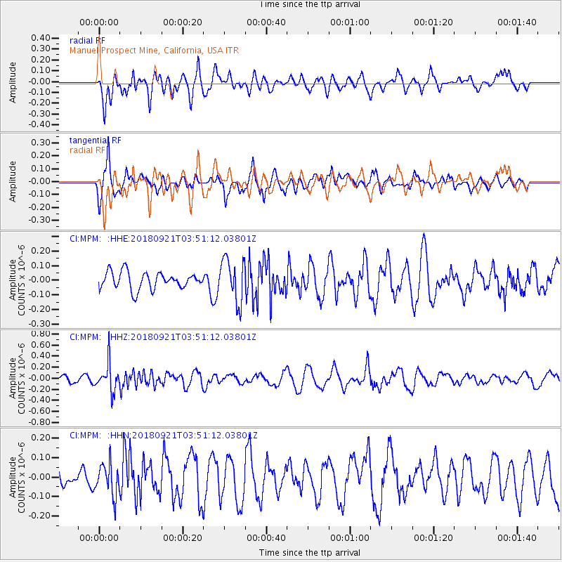
MPM Manuel Prospect Mine, California, USA - Earthquake Result Viewer
*The percent match for this event was below the threshold and hence no stack was calculated.
| Earthquake location: |
Fiji Islands Region |
| Earthquake latitude/longitude: |
-17.9/-179.9 |
| Earthquake time(UTC): |
2018/09/21 (264) 03:40:40 GMT |
| Earthquake Depth: |
653 km |
| Earthquake Magnitude: |
5.9 Mww |
| Earthquake Catalog/Contributor: |
NEIC PDE/us |
|
| Network: |
CI Caltech Regional Seismic Network |
| Station: |
MPM Manuel Prospect Mine, California, USA |
| Lat/Lon: |
36.06 N/117.49 W |
| Elevation: |
185 m |
|
| Distance: |
79.8 deg |
| Az: |
46.894 deg |
| Baz: |
239.081 deg |
| Ray Param: |
$rayparam |
*The percent match for this event was below the threshold and hence was not used in the summary stack. |
|
| Radial Match: |
68.83082 % |
| Radial Bump: |
400 |
| Transverse Match: |
59.53458 % |
| Transverse Bump: |
400 |
| SOD ConfigId: |
13570011 |
| Insert Time: |
2019-05-01 07:13:54.877 +0000 |
| GWidth: |
2.5 |
| Max Bumps: |
400 |
| Tol: |
0.001 |
|
Signal To Noise
| Channel | StoN | STA | LTA |
| CI:MPM: :HHZ:20180921T03:51:12.03801Z | 2.7600548 | 2.6286693E-7 | 9.523975E-8 |
| CI:MPM: :HHN:20180921T03:51:12.03801Z | 0.7966894 | 8.266105E-8 | 1.0375569E-7 |
| CI:MPM: :HHE:20180921T03:51:12.03801Z | 2.6122115 | 1.5149358E-7 | 5.7994377E-8 |
| Arrivals |
| Ps | |
| PpPs | |
| PsPs/PpSs | |


