You are here: Home > Network List > TA - USArray Transportable Network (new EarthScope stations) Stations List
> Station B18K Kokolik River, AK, USA > Earthquake Result Viewer
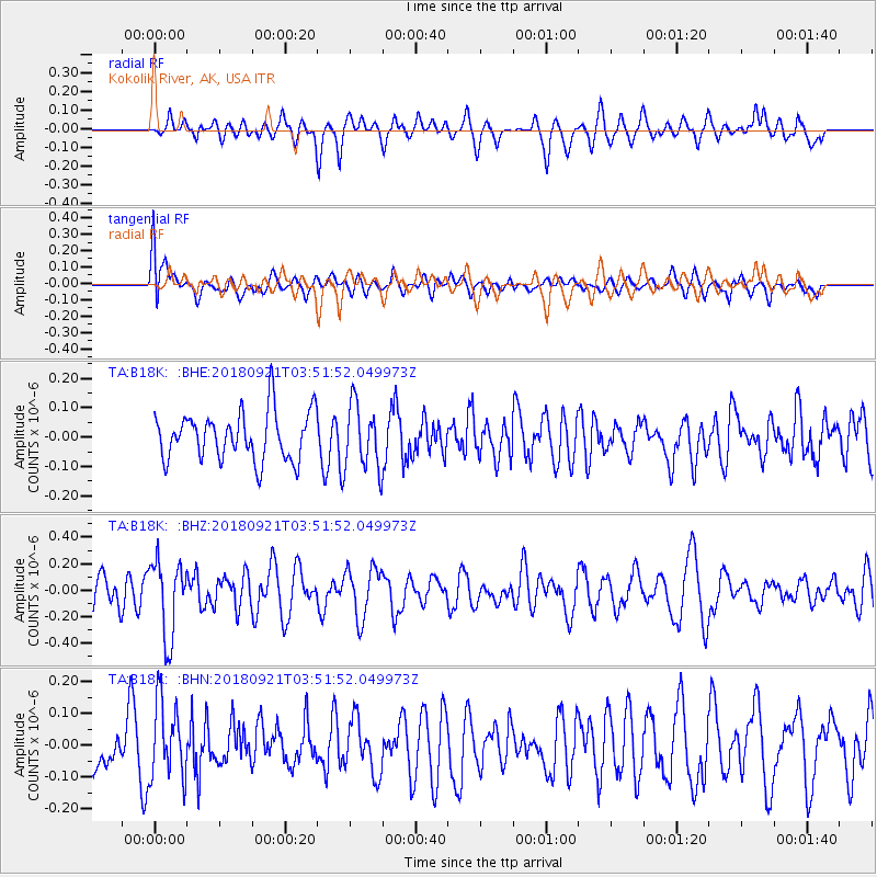
B18K Kokolik River, AK, USA - Earthquake Result Viewer
*The percent match for this event was below the threshold and hence no stack was calculated.
| Earthquake location: |
Fiji Islands Region |
| Earthquake latitude/longitude: |
-17.9/-179.9 |
| Earthquake time(UTC): |
2018/09/21 (264) 03:40:40 GMT |
| Earthquake Depth: |
653 km |
| Earthquake Magnitude: |
5.9 Mww |
| Earthquake Catalog/Contributor: |
NEIC PDE/us |
|
| Network: |
TA USArray Transportable Network (new EarthScope stations) |
| Station: |
B18K Kokolik River, AK, USA |
| Lat/Lon: |
69.36 N/161.80 W |
| Elevation: |
222 m |
|
| Distance: |
88.0 deg |
| Az: |
6.343 deg |
| Baz: |
197.262 deg |
| Ray Param: |
$rayparam |
*The percent match for this event was below the threshold and hence was not used in the summary stack. |
|
| Radial Match: |
52.644726 % |
| Radial Bump: |
400 |
| Transverse Match: |
46.441364 % |
| Transverse Bump: |
400 |
| SOD ConfigId: |
13570011 |
| Insert Time: |
2019-05-01 07:17:41.667 +0000 |
| GWidth: |
2.5 |
| Max Bumps: |
400 |
| Tol: |
0.001 |
|
Signal To Noise
| Channel | StoN | STA | LTA |
| TA:B18K: :BHZ:20180921T03:51:52.049973Z | 2.277463 | 2.9015155E-7 | 1.2740121E-7 |
| TA:B18K: :BHN:20180921T03:51:52.049973Z | 1.3709954 | 1.2077538E-7 | 8.80932E-8 |
| TA:B18K: :BHE:20180921T03:51:52.049973Z | 1.3478311 | 1.1074217E-7 | 8.216324E-8 |
| Arrivals |
| Ps | |
| PpPs | |
| PsPs/PpSs | |


