You are here: Home > Network List > UU - University of Utah Regional Network Stations List
> Station CCUT Cedar City, UT, USA > Earthquake Result Viewer
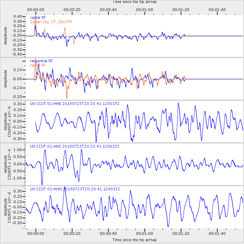
CCUT Cedar City, UT, USA - Earthquake Result Viewer
*The percent match for this event was below the threshold and hence no stack was calculated.
| Earthquake location: |
Tonga Islands |
| Earthquake latitude/longitude: |
-15.1/-173.6 |
| Earthquake time(UTC): |
2016/07/23 (205) 20:09:19 GMT |
| Earthquake Depth: |
10 km |
| Earthquake Magnitude: |
5.7 MB |
| Earthquake Catalog/Contributor: |
NEIC PDE/NEIC COMCAT |
|
| Network: |
UU University of Utah Regional Network |
| Station: |
CCUT Cedar City, UT, USA |
| Lat/Lon: |
37.55 N/113.36 W |
| Elevation: |
2127 m |
|
| Distance: |
77.1 deg |
| Az: |
45.078 deg |
| Baz: |
239.378 deg |
| Ray Param: |
$rayparam |
*The percent match for this event was below the threshold and hence was not used in the summary stack. |
|
| Radial Match: |
68.41321 % |
| Radial Bump: |
375 |
| Transverse Match: |
67.107086 % |
| Transverse Bump: |
400 |
| SOD ConfigId: |
1634031 |
| Insert Time: |
2016-08-06 20:32:57.118 +0000 |
| GWidth: |
2.5 |
| Max Bumps: |
400 |
| Tol: |
0.001 |
|
Signal To Noise
| Channel | StoN | STA | LTA |
| UU:CCUT:01:HHZ:20160723T20:20:41.120015Z | 3.840465 | 5.3428914E-7 | 1.3912094E-7 |
| UU:CCUT:01:HHN:20160723T20:20:41.120015Z | 1.2487088 | 1.1384368E-7 | 9.116912E-8 |
| UU:CCUT:01:HHE:20160723T20:20:41.120015Z | 1.6241065 | 1.3270369E-7 | 8.1708734E-8 |
| Arrivals |
| Ps | |
| PpPs | |
| PsPs/PpSs | |


