You are here: Home > Network List > TA - USArray Transportable Network (new EarthScope stations) Stations List
> Station 119A Ashpeak Ranch, Duncan, AZ, USA > Earthquake Result Viewer
119A Ashpeak Ranch, Duncan, AZ, USA - Earthquake Result Viewer
| Earthquake location: |
Easter Island Region |
| Earthquake latitude/longitude: |
-28.5/-112.8 |
| Earthquake time(UTC): |
2008/08/19 (232) 10:58:00 GMT |
| Earthquake Depth: |
9.0 km |
| Earthquake Magnitude: |
5.5 MB, 5.3 MS, 5.7 MW, 5.7 MW |
| Earthquake Catalog/Contributor: |
WHDF/NEIC |
|
| Network: |
TA USArray Transportable Network (new EarthScope stations) |
| Station: |
119A Ashpeak Ranch, Duncan, AZ, USA |
| Lat/Lon: |
32.77 N/109.30 W |
| Elevation: |
1406 m |
|
| Distance: |
61.1 deg |
| Az: |
3.407 deg |
| Baz: |
183.558 deg |
| Ray Param: |
0.06111832 |
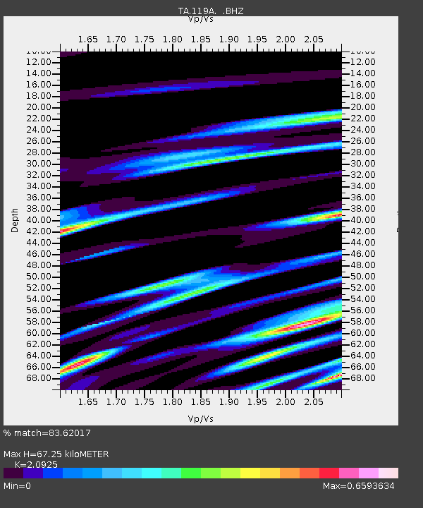
| Estimated Moho Depth: |
67.25 km |
| Estimated Crust Vp/Vs: |
2.09 |
| Assumed Crust Vp: |
6.276 km/s |
| Estimated Crust Vs: |
2.999 km/s |
| Estimated Crust Poisson's Ratio: |
0.35 |
|
| Radial Match: |
83.62017 % |
| Radial Bump: |
395 |
| Transverse Match: |
63.52132 % |
| Transverse Bump: |
400 |
| SOD ConfigId: |
2504 |
| Insert Time: |
2010-03-06 16:05:49.329 +0000 |
| GWidth: |
2.5 |
| Max Bumps: |
400 |
| Tol: |
0.001 |
|

Signal To Noise
| Channel | StoN | STA | LTA |
| TA:119A: :BHZ:20080819T11:07:43.173999Z | 6.8344765 | 5.8115745E-7 | 8.503321E-8 |
| TA:119A: :BHN:20080819T11:07:43.173999Z | 4.3486094 | 3.0576464E-7 | 7.03132E-8 |
| TA:119A: :BHE:20080819T11:07:43.173999Z | 0.40679577 | 5.0426532E-8 | 1.2396032E-7 |
| Arrivals |
| Ps | 12 SECOND |
| PpPs | 32 SECOND |
| PsPs/PpSs | 44 SECOND |


