You are here: Home > Network List > UW - Pacific Northwest Regional Seismic Network Stations List
> Station UMAT Pilot Rock, OR, USA > Earthquake Result Viewer
UMAT Pilot Rock, OR, USA - Earthquake Result Viewer
*The percent match for this event was below the threshold and hence no stack was calculated.
| Earthquake location: |
Fiji Islands Region |
| Earthquake latitude/longitude: |
-17.9/-179.9 |
| Earthquake time(UTC): |
2018/09/21 (264) 03:40:40 GMT |
| Earthquake Depth: |
653 km |
| Earthquake Magnitude: |
5.9 Mww |
| Earthquake Catalog/Contributor: |
NEIC PDE/us |
|
| Network: |
UW Pacific Northwest Regional Seismic Network |
| Station: |
UMAT Pilot Rock, OR, USA |
| Lat/Lon: |
45.29 N/118.96 W |
| Elevation: |
1318 m |
|
| Distance: |
83.7 deg |
| Az: |
38.394 deg |
| Baz: |
236.9 deg |
| Ray Param: |
$rayparam |
*The percent match for this event was below the threshold and hence was not used in the summary stack. |
|
| Radial Match: |
70.15622 % |
| Radial Bump: |
400 |
| Transverse Match: |
64.05118 % |
| Transverse Bump: |
400 |
| SOD ConfigId: |
13570011 |
| Insert Time: |
2019-05-01 07:21:45.682 +0000 |
| GWidth: |
2.5 |
| Max Bumps: |
400 |
| Tol: |
0.001 |
|
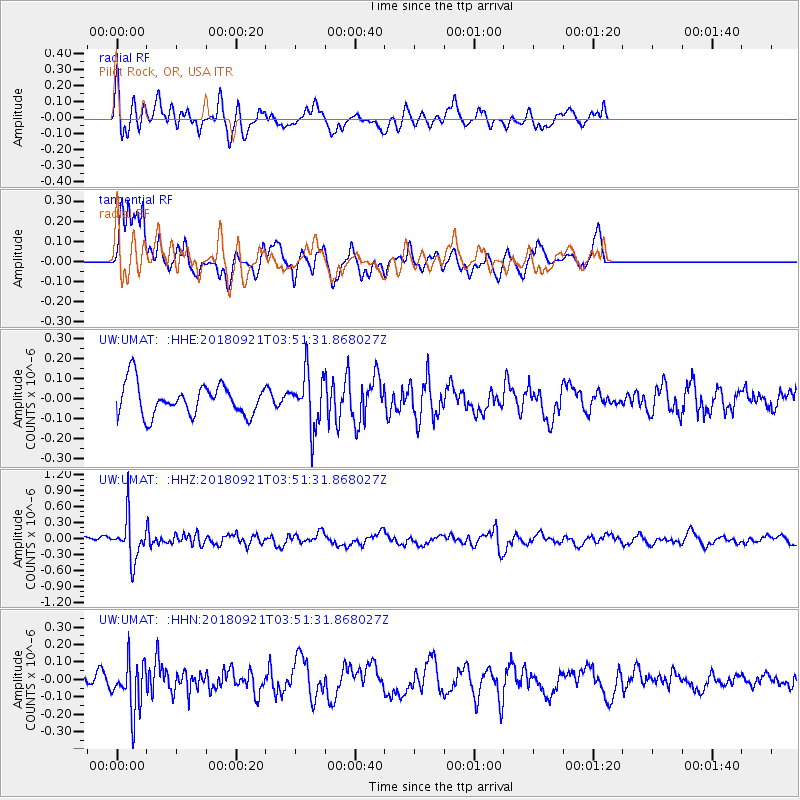
Signal To Noise
| Channel | StoN | STA | LTA |
| UW:UMAT: :HHZ:20180921T03:51:31.868027Z | 4.71242 | 4.0187496E-7 | 8.527995E-8 |
| UW:UMAT: :HHN:20180921T03:51:31.868027Z | 2.0188522 | 1.4462715E-7 | 7.1638304E-8 |
| UW:UMAT: :HHE:20180921T03:51:31.868027Z | 1.6808515 | 1.3207004E-7 | 7.8573294E-8 |
| Arrivals |
| Ps | |
| PpPs | |
| PsPs/PpSs | |


