You are here: Home > Network List > TA - USArray Transportable Network (new EarthScope stations) Stations List
> Station I17K Unalakleet, AK, USA > Earthquake Result Viewer
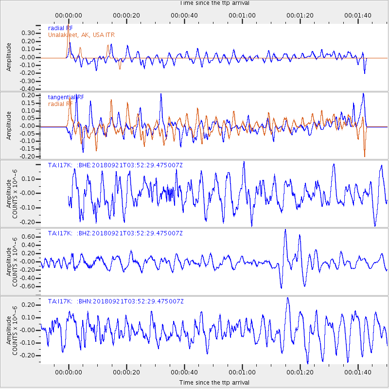
I17K Unalakleet, AK, USA - Earthquake Result Viewer
*The percent match for this event was below the threshold and hence no stack was calculated.
| Earthquake location: |
Fiji Islands Region |
| Earthquake latitude/longitude: |
-17.8/-179.9 |
| Earthquake time(UTC): |
2018/09/21 (264) 03:41:41 GMT |
| Earthquake Depth: |
639 km |
| Earthquake Magnitude: |
5.7 Mwb |
| Earthquake Catalog/Contributor: |
NEIC PDE/us |
|
| Network: |
TA USArray Transportable Network (new EarthScope stations) |
| Station: |
I17K Unalakleet, AK, USA |
| Lat/Lon: |
63.89 N/160.70 W |
| Elevation: |
105 m |
|
| Distance: |
82.8 deg |
| Az: |
8.429 deg |
| Baz: |
198.391 deg |
| Ray Param: |
$rayparam |
*The percent match for this event was below the threshold and hence was not used in the summary stack. |
|
| Radial Match: |
50.360348 % |
| Radial Bump: |
400 |
| Transverse Match: |
57.481853 % |
| Transverse Bump: |
400 |
| SOD ConfigId: |
13570011 |
| Insert Time: |
2019-05-01 07:27:56.835 +0000 |
| GWidth: |
2.5 |
| Max Bumps: |
400 |
| Tol: |
0.001 |
|
Signal To Noise
| Channel | StoN | STA | LTA |
| TA:I17K: :BHZ:20180921T03:52:29.475007Z | 1.2146256 | 1.225982E-7 | 1.0093496E-7 |
| TA:I17K: :BHN:20180921T03:52:29.475007Z | 1.9172031 | 1.0839274E-7 | 5.6536912E-8 |
| TA:I17K: :BHE:20180921T03:52:29.475007Z | 0.5494182 | 5.3024646E-8 | 9.651053E-8 |
| Arrivals |
| Ps | |
| PpPs | |
| PsPs/PpSs | |


