You are here: Home > Network List > TA - USArray Transportable Network (new EarthScope stations) Stations List
> Station R31K City Hall, Gustavus, AK, USA > Earthquake Result Viewer
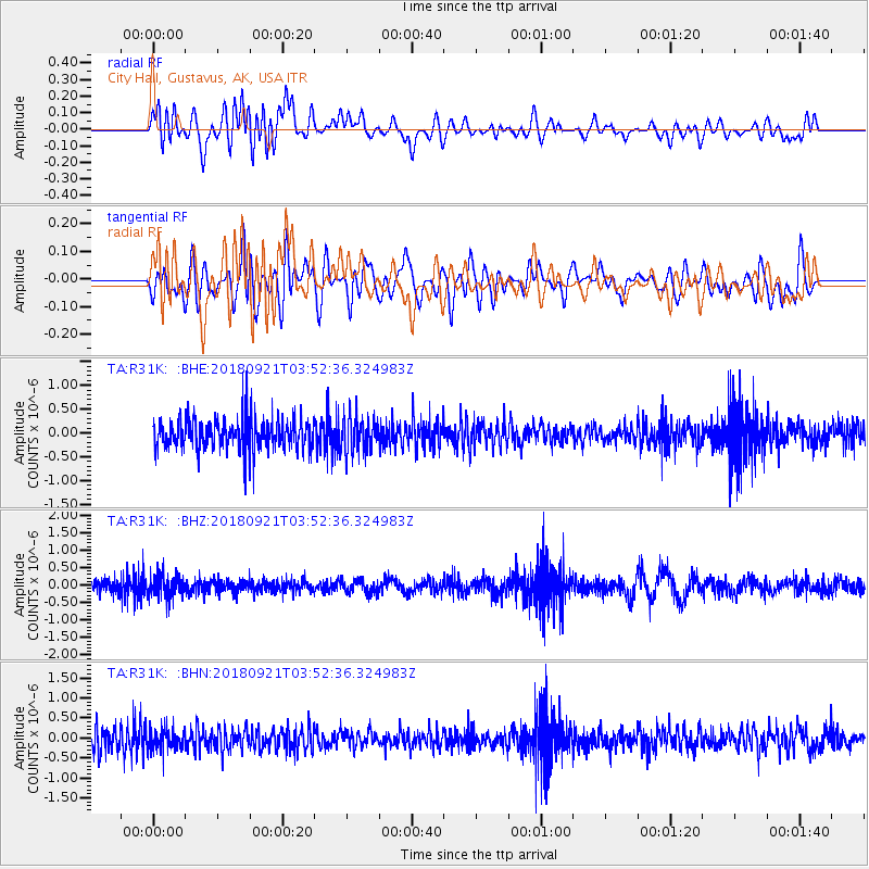
R31K City Hall, Gustavus, AK, USA - Earthquake Result Viewer
*The percent match for this event was below the threshold and hence no stack was calculated.
| Earthquake location: |
Fiji Islands Region |
| Earthquake latitude/longitude: |
-17.8/-179.9 |
| Earthquake time(UTC): |
2018/09/21 (264) 03:41:41 GMT |
| Earthquake Depth: |
639 km |
| Earthquake Magnitude: |
5.7 Mwb |
| Earthquake Catalog/Contributor: |
NEIC PDE/us |
|
| Network: |
TA USArray Transportable Network (new EarthScope stations) |
| Station: |
R31K City Hall, Gustavus, AK, USA |
| Lat/Lon: |
58.41 N/135.74 W |
| Elevation: |
15 m |
|
| Distance: |
84.2 deg |
| Az: |
21.619 deg |
| Baz: |
221.819 deg |
| Ray Param: |
$rayparam |
*The percent match for this event was below the threshold and hence was not used in the summary stack. |
|
| Radial Match: |
48.114983 % |
| Radial Bump: |
400 |
| Transverse Match: |
42.92845 % |
| Transverse Bump: |
400 |
| SOD ConfigId: |
13570011 |
| Insert Time: |
2019-05-01 07:28:27.709 +0000 |
| GWidth: |
2.5 |
| Max Bumps: |
400 |
| Tol: |
0.001 |
|
Signal To Noise
| Channel | StoN | STA | LTA |
| TA:R31K: :BHZ:20180921T03:52:36.324983Z | 1.5916711 | 3.220137E-7 | 2.023117E-7 |
| TA:R31K: :BHN:20180921T03:52:36.324983Z | 0.75695074 | 2.5058492E-7 | 3.3104521E-7 |
| TA:R31K: :BHE:20180921T03:52:36.324983Z | 1.1178637 | 3.6953412E-7 | 3.3057174E-7 |
| Arrivals |
| Ps | |
| PpPs | |
| PsPs/PpSs | |


