You are here: Home > Network List > TA - USArray Transportable Network (new EarthScope stations) Stations List
> Station 119A Ashpeak Ranch, Duncan, AZ, USA > Earthquake Result Viewer
119A Ashpeak Ranch, Duncan, AZ, USA - Earthquake Result Viewer
| Earthquake location: |
South Of Fiji Islands |
| Earthquake latitude/longitude: |
-25.8/179.5 |
| Earthquake time(UTC): |
2007/10/16 (289) 21:05:43 GMT |
| Earthquake Depth: |
509 km |
| Earthquake Magnitude: |
6.2 MB, 6.6 MW, 6.5 MW |
| Earthquake Catalog/Contributor: |
WHDF/NEIC |
|
| Network: |
TA USArray Transportable Network (new EarthScope stations) |
| Station: |
119A Ashpeak Ranch, Duncan, AZ, USA |
| Lat/Lon: |
32.77 N/109.30 W |
| Elevation: |
1406 m |
|
| Distance: |
89.3 deg |
| Az: |
52.891 deg |
| Baz: |
238.588 deg |
| Ray Param: |
0.041620713 |
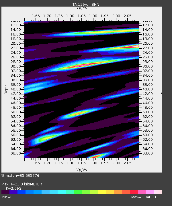
| Estimated Moho Depth: |
21.0 km |
| Estimated Crust Vp/Vs: |
2.10 |
| Assumed Crust Vp: |
6.276 km/s |
| Estimated Crust Vs: |
2.996 km/s |
| Estimated Crust Poisson's Ratio: |
0.35 |
|
| Radial Match: |
85.685776 % |
| Radial Bump: |
395 |
| Transverse Match: |
76.45336 % |
| Transverse Bump: |
400 |
| SOD ConfigId: |
2564 |
| Insert Time: |
2010-03-06 16:06:40.400 +0000 |
| GWidth: |
2.5 |
| Max Bumps: |
400 |
| Tol: |
0.001 |
|
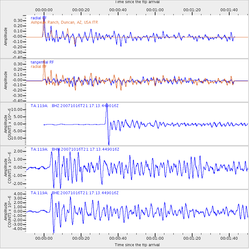
Signal To Noise
| Channel | StoN | STA | LTA |
| TA:119A: :BHN:20071016T21:17:13.449016Z | 5.051999 | 7.3454225E-7 | 1.4539637E-7 |
| TA:119A: :BHE:20071016T21:17:13.449016Z | 7.279962 | 1.4739073E-6 | 2.0246087E-7 |
| TA:119A: :BHZ:20071016T21:17:13.449016Z | 34.33932 | 5.084127E-6 | 1.4805556E-7 |
| Arrivals |
| Ps | 3.7 SECOND |
| PpPs | 10 SECOND |
| PsPs/PpSs | 14 SECOND |


