You are here: Home > Network List > TA - USArray Transportable Network (new EarthScope stations) Stations List
> Station 119A Ashpeak Ranch, Duncan, AZ, USA > Earthquake Result Viewer
119A Ashpeak Ranch, Duncan, AZ, USA - Earthquake Result Viewer
| Earthquake location: |
Near Coast Of Peru |
| Earthquake latitude/longitude: |
-13.6/-76.6 |
| Earthquake time(UTC): |
2007/08/17 (229) 13:18:13 GMT |
| Earthquake Depth: |
48 km |
| Earthquake Magnitude: |
5.6 MB, 5.6 MS, 5.9 MW |
| Earthquake Catalog/Contributor: |
WHDF/NEIC |
|
| Network: |
TA USArray Transportable Network (new EarthScope stations) |
| Station: |
119A Ashpeak Ranch, Duncan, AZ, USA |
| Lat/Lon: |
32.77 N/109.30 W |
| Elevation: |
1406 m |
|
| Distance: |
55.7 deg |
| Az: |
326.565 deg |
| Baz: |
140.517 deg |
| Ray Param: |
0.06450512 |
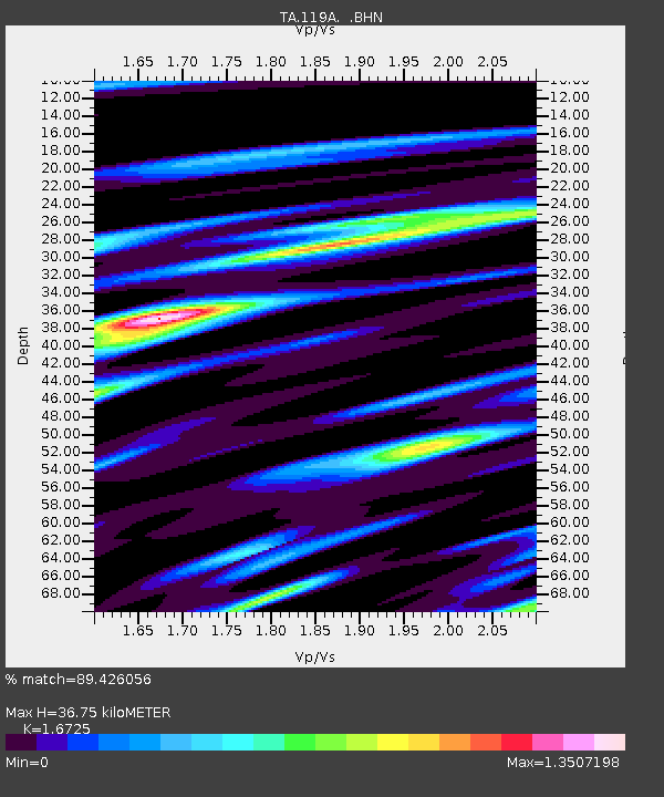
| Estimated Moho Depth: |
36.75 km |
| Estimated Crust Vp/Vs: |
1.67 |
| Assumed Crust Vp: |
6.276 km/s |
| Estimated Crust Vs: |
3.752 km/s |
| Estimated Crust Poisson's Ratio: |
0.22 |
|
| Radial Match: |
89.426056 % |
| Radial Bump: |
400 |
| Transverse Match: |
81.41417 % |
| Transverse Bump: |
400 |
| SOD ConfigId: |
2564 |
| Insert Time: |
2010-03-06 16:06:50.152 +0000 |
| GWidth: |
2.5 |
| Max Bumps: |
400 |
| Tol: |
0.001 |
|
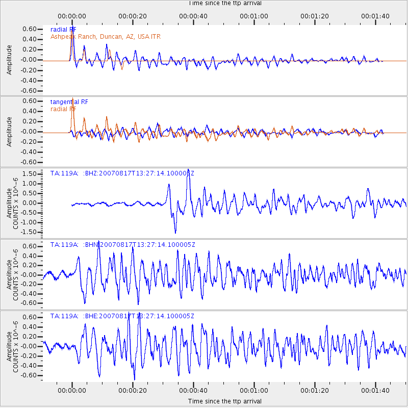
Signal To Noise
| Channel | StoN | STA | LTA |
| TA:119A: :BHN:20070817T13:27:14.100005Z | 5.255483 | 2.7895794E-7 | 5.307941E-8 |
| TA:119A: :BHE:20070817T13:27:14.100005Z | 3.810177 | 2.1791267E-7 | 5.719227E-8 |
| TA:119A: :BHZ:20070817T13:27:14.100005Z | 10.950968 | 6.38608E-7 | 5.8315212E-8 |
| Arrivals |
| Ps | 4.1 SECOND |
| PpPs | 15 SECOND |
| PsPs/PpSs | 19 SECOND |


