You are here: Home > Network List > TA - USArray Transportable Network (new EarthScope stations) Stations List
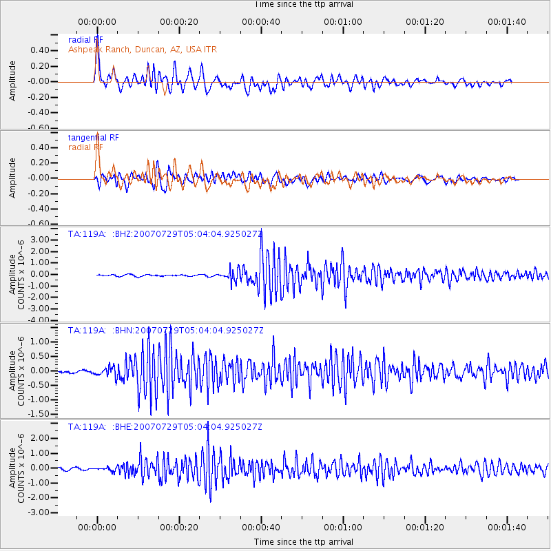
> Station 119A Ashpeak Ranch, Duncan, AZ, USA > Earthquake Result Viewer
119A Ashpeak Ranch, Duncan, AZ, USA - Earthquake Result Viewer
| Earthquake location: |
Komandorskiye Ostrova Region |
| Earthquake latitude/longitude: |
53.6/169.7 |
| Earthquake time(UTC): |
2007/07/29 (210) 04:54:36 GMT |
| Earthquake Depth: |
26 km |
| Earthquake Magnitude: |
6.0 MB, 5.5 MS, 5.9 MW, 5.8 MW |
| Earthquake Catalog/Contributor: |
WHDF/NEIC |
|
| Network: |
TA USArray Transportable Network (new EarthScope stations) |
| Station: |
119A Ashpeak Ranch, Duncan, AZ, USA |
| Lat/Lon: |
32.77 N/109.30 W |
| Elevation: |
1406 m |
|
| Distance: |
59.3 deg |
| Az: |
75.528 deg |
| Baz: |
316.821 deg |
| Ray Param: |
0.062273644 |
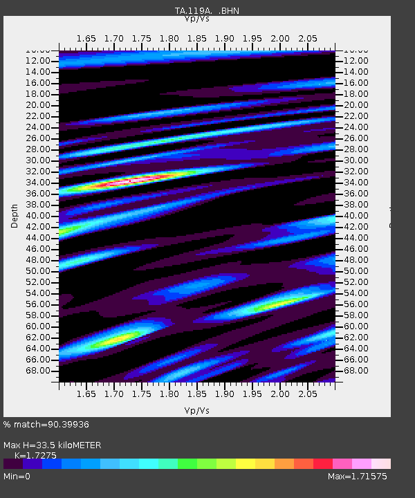
| Estimated Moho Depth: |
33.5 km |
| Estimated Crust Vp/Vs: |
1.73 |
| Assumed Crust Vp: |
6.276 km/s |
| Estimated Crust Vs: |
3.633 km/s |
| Estimated Crust Poisson's Ratio: |
0.25 |
|
| Radial Match: |
90.39936 % |
| Radial Bump: |
400 |
| Transverse Match: |
89.019325 % |
| Transverse Bump: |
400 |
| SOD ConfigId: |
2564 |
| Insert Time: |
2010-03-06 16:07:01.014 +0000 |
| GWidth: |
2.5 |
| Max Bumps: |
400 |
| Tol: |
0.001 |
|
Signal To Noise
| Channel | StoN | STA | LTA |
| TA:119A: :BHN:20070729T05:04:04.925027Z | 2.6205995 | 1.6015399E-7 | 6.111349E-8 |
| TA:119A: :BHE:20070729T05:04:04.925027Z | 1.7414529 | 1.12514165E-7 | 6.460936E-8 |
| TA:119A: :BHZ:20070729T05:04:04.925027Z | 6.6874337 | 4.5459907E-7 | 6.797811E-8 |
| Arrivals |
| Ps | 4.1 SECOND |
| PpPs | 14 SECOND |
| PsPs/PpSs | 18 SECOND |


