You are here: Home > Network List > TA - USArray Transportable Network (new EarthScope stations) Stations List
> Station 119A Ashpeak Ranch, Duncan, AZ, USA > Earthquake Result Viewer
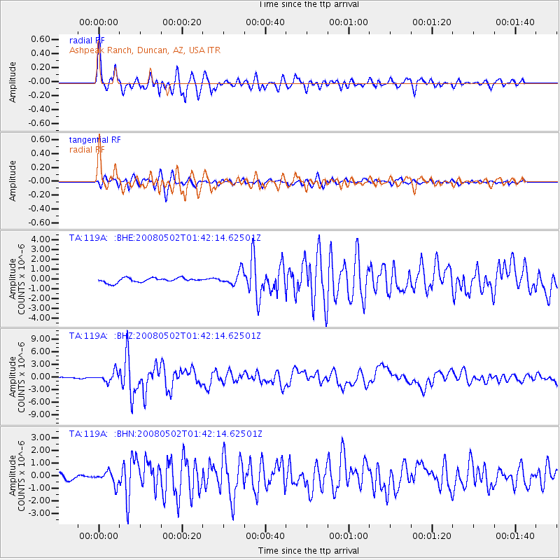
119A Ashpeak Ranch, Duncan, AZ, USA - Earthquake Result Viewer
| Earthquake location: |
Andreanof Islands, Aleutian Is. |
| Earthquake latitude/longitude: |
51.9/-177.5 |
| Earthquake time(UTC): |
2008/05/02 (123) 01:33:37 GMT |
| Earthquake Depth: |
14 km |
| Earthquake Magnitude: |
6.3 MB, 6.8 MS, 6.6 MW, 6.6 MW |
| Earthquake Catalog/Contributor: |
WHDF/NEIC |
|
| Network: |
TA USArray Transportable Network (new EarthScope stations) |
| Station: |
119A Ashpeak Ranch, Duncan, AZ, USA |
| Lat/Lon: |
32.77 N/109.30 W |
| Elevation: |
1406 m |
|
| Distance: |
51.9 deg |
| Az: |
83.524 deg |
| Baz: |
313.005 deg |
| Ray Param: |
0.06706798 |
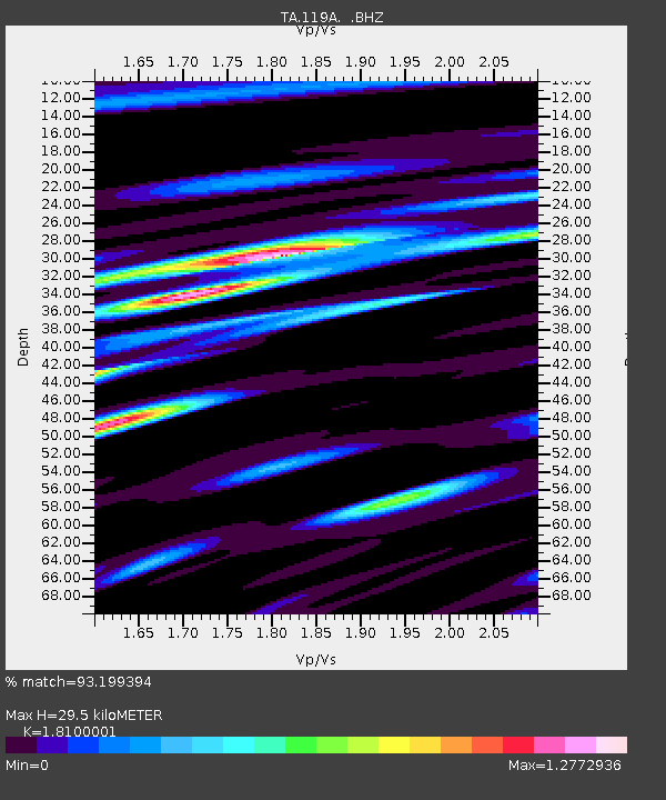
| Estimated Moho Depth: |
29.5 km |
| Estimated Crust Vp/Vs: |
1.81 |
| Assumed Crust Vp: |
6.276 km/s |
| Estimated Crust Vs: |
3.467 km/s |
| Estimated Crust Poisson's Ratio: |
0.28 |
|
| Radial Match: |
93.199394 % |
| Radial Bump: |
400 |
| Transverse Match: |
83.7528 % |
| Transverse Bump: |
400 |
| SOD ConfigId: |
2504 |
| Insert Time: |
2010-03-06 16:07:31.345 +0000 |
| GWidth: |
2.5 |
| Max Bumps: |
400 |
| Tol: |
0.001 |
|
Signal To Noise
| Channel | StoN | STA | LTA |
| TA:119A: :BHZ:20080502T01:42:14.62501Z | 4.8683195 | 1.1878436E-6 | 2.4399458E-7 |
| TA:119A: :BHN:20080502T01:42:14.62501Z | 2.0745404 | 5.228401E-7 | 2.5202695E-7 |
| TA:119A: :BHE:20080502T01:42:14.62501Z | 3.1240888 | 7.036277E-7 | 2.2522653E-7 |
| Arrivals |
| Ps | 4.0 SECOND |
| PpPs | 13 SECOND |
| PsPs/PpSs | 17 SECOND |


