You are here: Home > Network List > GS - US Geological Survey Networks Stations List
> Station KAN10 Keim Farm > Earthquake Result Viewer
KAN10 Keim Farm - Earthquake Result Viewer
*The percent match for this event was below the threshold and hence no stack was calculated.
| Earthquake location: |
Southeast Of Easter Island |
| Earthquake latitude/longitude: |
-35.8/-103.3 |
| Earthquake time(UTC): |
2016/07/10 (192) 02:32:42 GMT |
| Earthquake Depth: |
10 km |
| Earthquake Magnitude: |
5.6 MWC, 5.6 MWC |
| Earthquake Catalog/Contributor: |
NEIC PDE/NEIC COMCAT |
|
| Network: |
GS US Geological Survey Networks |
| Station: |
KAN10 Keim Farm |
| Lat/Lon: |
37.12 N/98.10 W |
| Elevation: |
417 m |
|
| Distance: |
72.7 deg |
| Az: |
4.314 deg |
| Baz: |
184.387 deg |
| Ray Param: |
$rayparam |
*The percent match for this event was below the threshold and hence was not used in the summary stack. |
|
| Radial Match: |
65.66783 % |
| Radial Bump: |
400 |
| Transverse Match: |
58.526608 % |
| Transverse Bump: |
400 |
| SOD ConfigId: |
1634031 |
| Insert Time: |
2016-08-06 22:44:50.434 +0000 |
| GWidth: |
2.5 |
| Max Bumps: |
400 |
| Tol: |
0.001 |
|
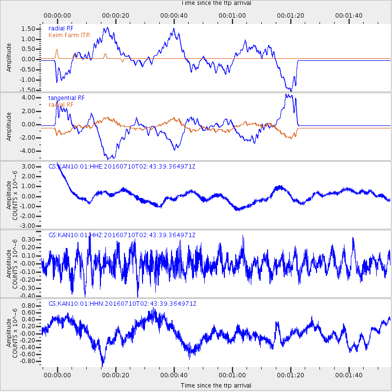
Signal To Noise
| Channel | StoN | STA | LTA |
| GS:KAN10:01:HHZ:20160710T02:43:39.364971Z | 1.3600736 | 1.099153E-7 | 8.08157E-8 |
| GS:KAN10:01:HHN:20160710T02:43:39.364971Z | 4.0543957 | 7.154896E-7 | 1.7647255E-7 |
| GS:KAN10:01:HHE:20160710T02:43:39.364971Z | 1.4142038 | 1.209015E-6 | 8.549086E-7 |
| Arrivals |
| Ps | |
| PpPs | |
| PsPs/PpSs | |


