You are here: Home > Network List > TA - USArray Transportable Network (new EarthScope stations) Stations List
> Station 119A Ashpeak Ranch, Duncan, AZ, USA > Earthquake Result Viewer
119A Ashpeak Ranch, Duncan, AZ, USA - Earthquake Result Viewer
| Earthquake location: |
Tonga Islands |
| Earthquake latitude/longitude: |
-20.8/-173.3 |
| Earthquake time(UTC): |
2008/06/26 (178) 21:19:15 GMT |
| Earthquake Depth: |
38 km |
| Earthquake Magnitude: |
6.0 MB, 5.8 MS, 6.2 MW, 6.1 MW |
| Earthquake Catalog/Contributor: |
WHDF/NEIC |
|
| Network: |
TA USArray Transportable Network (new EarthScope stations) |
| Station: |
119A Ashpeak Ranch, Duncan, AZ, USA |
| Lat/Lon: |
32.77 N/109.30 W |
| Elevation: |
1406 m |
|
| Distance: |
81.1 deg |
| Az: |
50.069 deg |
| Baz: |
238.398 deg |
| Ray Param: |
0.04778957 |
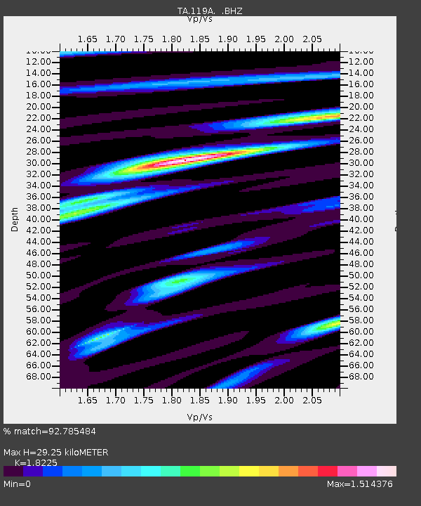
| Estimated Moho Depth: |
29.25 km |
| Estimated Crust Vp/Vs: |
1.82 |
| Assumed Crust Vp: |
6.276 km/s |
| Estimated Crust Vs: |
3.444 km/s |
| Estimated Crust Poisson's Ratio: |
0.28 |
|
| Radial Match: |
92.785484 % |
| Radial Bump: |
400 |
| Transverse Match: |
78.623215 % |
| Transverse Bump: |
400 |
| SOD ConfigId: |
2504 |
| Insert Time: |
2010-03-06 16:07:40.869 +0000 |
| GWidth: |
2.5 |
| Max Bumps: |
400 |
| Tol: |
0.001 |
|

Signal To Noise
| Channel | StoN | STA | LTA |
| TA:119A: :BHZ:20080626T21:30:55.624006Z | 22.75024 | 1.945285E-6 | 8.550613E-8 |
| TA:119A: :BHN:20080626T21:30:55.624006Z | 3.702498 | 3.1224158E-7 | 8.433268E-8 |
| TA:119A: :BHE:20080626T21:30:55.624006Z | 6.014422 | 5.094382E-7 | 8.470277E-8 |
| Arrivals |
| Ps | 3.9 SECOND |
| PpPs | 13 SECOND |
| PsPs/PpSs | 17 SECOND |


