You are here: Home > Network List > TA - USArray Transportable Network (new EarthScope stations) Stations List
> Station D25K Kavik River, AK, USA > Earthquake Result Viewer
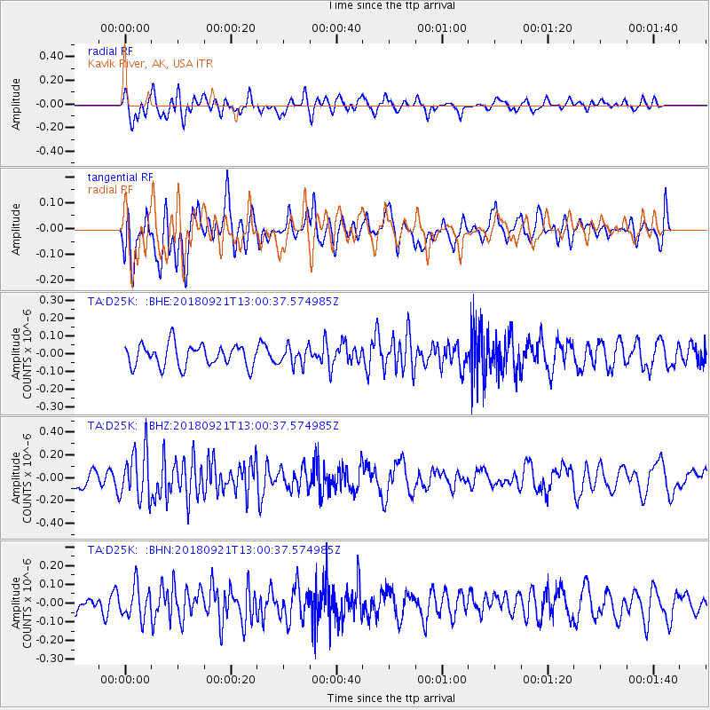
D25K Kavik River, AK, USA - Earthquake Result Viewer
*The percent match for this event was below the threshold and hence no stack was calculated.
| Earthquake location: |
Galapagos Islands Region |
| Earthquake latitude/longitude: |
2.4/-95.5 |
| Earthquake time(UTC): |
2018/09/21 (264) 12:49:28 GMT |
| Earthquake Depth: |
10 km |
| Earthquake Magnitude: |
5.7 Mww |
| Earthquake Catalog/Contributor: |
NEIC PDE/us |
|
| Network: |
TA USArray Transportable Network (new EarthScope stations) |
| Station: |
D25K Kavik River, AK, USA |
| Lat/Lon: |
69.32 N/146.38 W |
| Elevation: |
770 m |
|
| Distance: |
74.8 deg |
| Az: |
343.4 deg |
| Baz: |
126.524 deg |
| Ray Param: |
$rayparam |
*The percent match for this event was below the threshold and hence was not used in the summary stack. |
|
| Radial Match: |
67.17396 % |
| Radial Bump: |
400 |
| Transverse Match: |
61.29926 % |
| Transverse Bump: |
400 |
| SOD ConfigId: |
13570011 |
| Insert Time: |
2019-05-01 07:37:58.995 +0000 |
| GWidth: |
2.5 |
| Max Bumps: |
400 |
| Tol: |
0.001 |
|
Signal To Noise
| Channel | StoN | STA | LTA |
| TA:D25K: :BHZ:20180921T13:00:37.574985Z | 2.404635 | 2.1987778E-7 | 9.143915E-8 |
| TA:D25K: :BHN:20180921T13:00:37.574985Z | 1.4762369 | 8.689639E-8 | 5.8863446E-8 |
| TA:D25K: :BHE:20180921T13:00:37.574985Z | 0.83136964 | 5.1386255E-8 | 6.180915E-8 |
| Arrivals |
| Ps | |
| PpPs | |
| PsPs/PpSs | |


