You are here: Home > Network List > TA - USArray Transportable Network (new EarthScope stations) Stations List
> Station T25A Trinidad, CO, USA > Earthquake Result Viewer
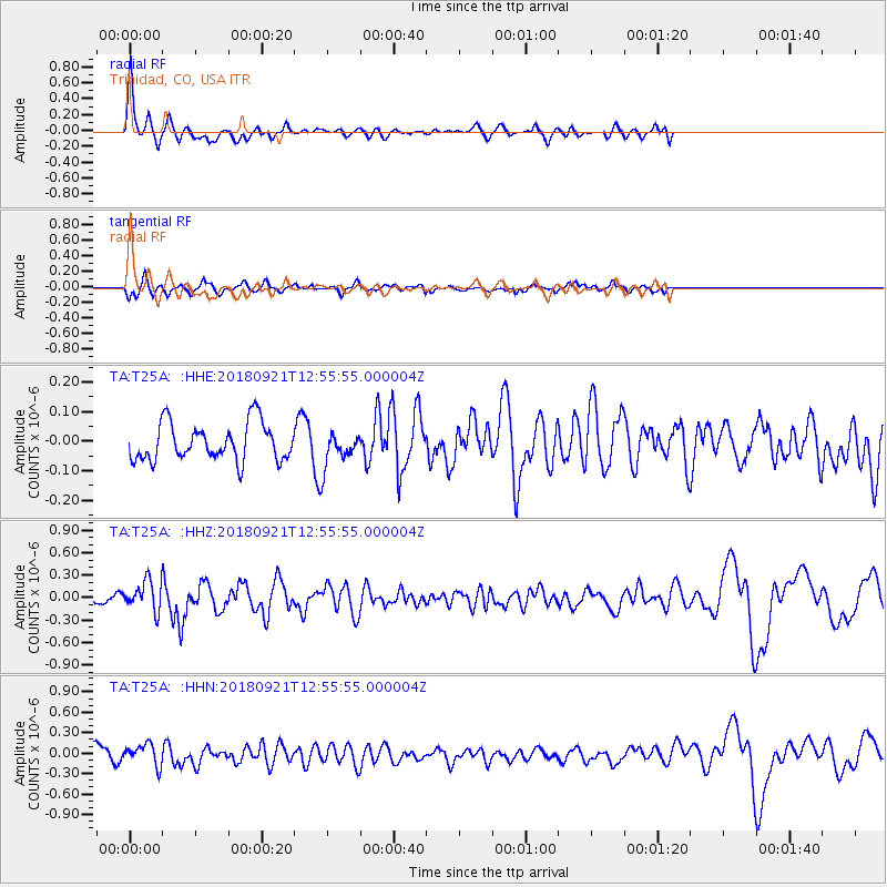
T25A Trinidad, CO, USA - Earthquake Result Viewer
*The percent match for this event was below the threshold and hence no stack was calculated.
| Earthquake location: |
Galapagos Islands Region |
| Earthquake latitude/longitude: |
2.4/-95.5 |
| Earthquake time(UTC): |
2018/09/21 (264) 12:49:28 GMT |
| Earthquake Depth: |
10 km |
| Earthquake Magnitude: |
5.7 Mww |
| Earthquake Catalog/Contributor: |
NEIC PDE/us |
|
| Network: |
TA USArray Transportable Network (new EarthScope stations) |
| Station: |
T25A Trinidad, CO, USA |
| Lat/Lon: |
37.14 N/104.41 W |
| Elevation: |
2017 m |
|
| Distance: |
35.5 deg |
| Az: |
347.669 deg |
| Baz: |
164.514 deg |
| Ray Param: |
$rayparam |
*The percent match for this event was below the threshold and hence was not used in the summary stack. |
|
| Radial Match: |
78.87792 % |
| Radial Bump: |
350 |
| Transverse Match: |
67.82315 % |
| Transverse Bump: |
400 |
| SOD ConfigId: |
13570011 |
| Insert Time: |
2019-05-01 07:38:50.178 +0000 |
| GWidth: |
2.5 |
| Max Bumps: |
400 |
| Tol: |
0.001 |
|
Signal To Noise
| Channel | StoN | STA | LTA |
| TA:T25A: :HHZ:20180921T12:55:55.000004Z | 3.9288566 | 1.9303174E-7 | 4.9131785E-8 |
| TA:T25A: :HHN:20180921T12:55:55.000004Z | 1.6579281 | 1.5687219E-7 | 9.461941E-8 |
| TA:T25A: :HHE:20180921T12:55:55.000004Z | 0.96006185 | 6.099705E-8 | 6.35345E-8 |
| Arrivals |
| Ps | |
| PpPs | |
| PsPs/PpSs | |


