You are here: Home > Network List > TA - USArray Transportable Network (new EarthScope stations) Stations List
> Station 119A Ashpeak Ranch, Duncan, AZ, USA > Earthquake Result Viewer
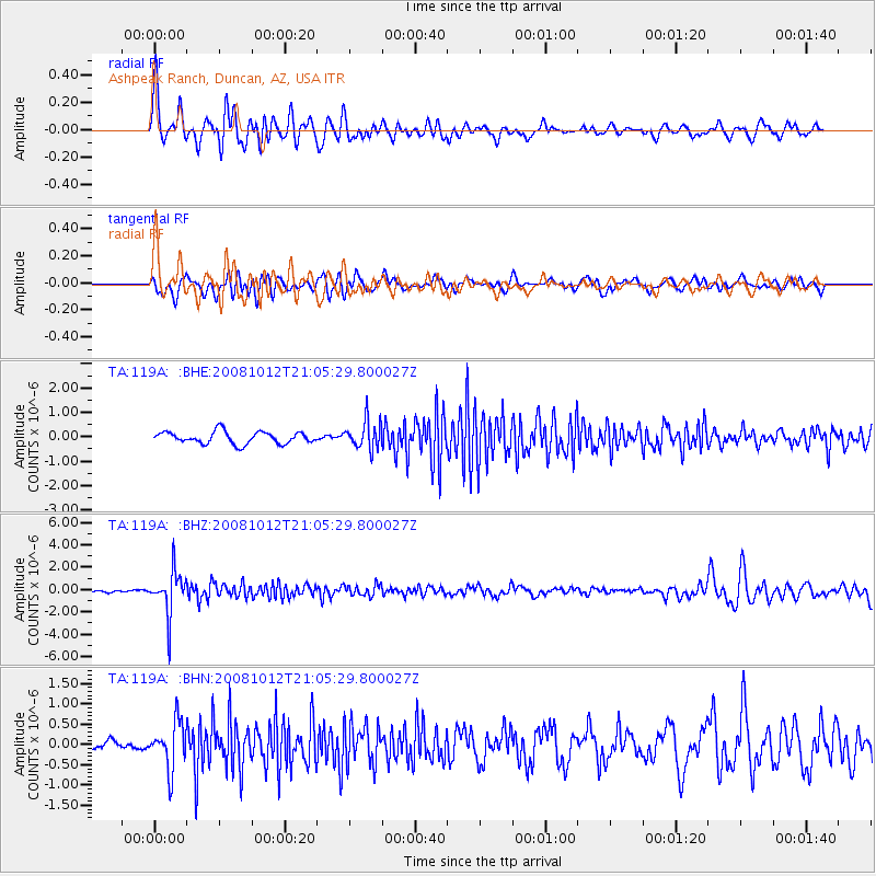
119A Ashpeak Ranch, Duncan, AZ, USA - Earthquake Result Viewer
*The percent match for this event was below the threshold and hence no stack was calculated.
| Earthquake location: |
Southern Bolivia |
| Earthquake latitude/longitude: |
-20.1/-65.0 |
| Earthquake time(UTC): |
2008/10/12 (286) 20:55:41 GMT |
| Earthquake Depth: |
353 km |
| Earthquake Magnitude: |
6.0 MB, 6.2 MW, 6.2 MW |
| Earthquake Catalog/Contributor: |
WHDF/NEIC |
|
| Network: |
TA USArray Transportable Network (new EarthScope stations) |
| Station: |
119A Ashpeak Ranch, Duncan, AZ, USA |
| Lat/Lon: |
32.77 N/109.30 W |
| Elevation: |
1406 m |
|
| Distance: |
67.5 deg |
| Az: |
320.423 deg |
| Baz: |
134.717 deg |
| Ray Param: |
$rayparam |
*The percent match for this event was below the threshold and hence was not used in the summary stack. |
|
| Radial Match: |
72.64635 % |
| Radial Bump: |
400 |
| Transverse Match: |
62.651577 % |
| Transverse Bump: |
400 |
| SOD ConfigId: |
2560 |
| Insert Time: |
2010-03-06 16:08:21.233 +0000 |
| GWidth: |
2.5 |
| Max Bumps: |
400 |
| Tol: |
0.001 |
|
Signal To Noise
| Channel | StoN | STA | LTA |
| TA:119A: :BHZ:20081012T21:05:29.800027Z | 6.8366685 | 1.9408556E-6 | 2.838891E-7 |
| TA:119A: :BHN:20081012T21:05:29.800027Z | 1.5648973 | 5.7561107E-7 | 3.6782674E-7 |
| TA:119A: :BHE:20081012T21:05:29.800027Z | 2.329789 | 5.6754396E-7 | 2.4360315E-7 |
| Arrivals |
| Ps | |
| PpPs | |
| PsPs/PpSs | |


