You are here: Home > Network List > AV - Alaska Volcano Observatory Stations List
> Station SPCR Ckakachatna River, Mount Spurr, Alaska > Earthquake Result Viewer
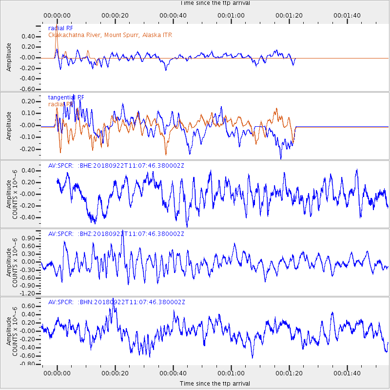
SPCR Ckakachatna River, Mount Spurr, Alaska - Earthquake Result Viewer
*The percent match for this event was below the threshold and hence no stack was calculated.
| Earthquake location: |
Ryukyu Islands, Japan |
| Earthquake latitude/longitude: |
26.7/129.6 |
| Earthquake time(UTC): |
2018/09/22 (265) 10:58:01 GMT |
| Earthquake Depth: |
10 km |
| Earthquake Magnitude: |
5.5 Mww |
| Earthquake Catalog/Contributor: |
NEIC PDE/us |
|
| Network: |
AV Alaska Volcano Observatory |
| Station: |
SPCR Ckakachatna River, Mount Spurr, Alaska |
| Lat/Lon: |
61.20 N/152.21 W |
| Elevation: |
984 m |
|
| Distance: |
61.3 deg |
| Az: |
32.688 deg |
| Baz: |
273.612 deg |
| Ray Param: |
$rayparam |
*The percent match for this event was below the threshold and hence was not used in the summary stack. |
|
| Radial Match: |
52.879646 % |
| Radial Bump: |
400 |
| Transverse Match: |
67.21528 % |
| Transverse Bump: |
400 |
| SOD ConfigId: |
13570011 |
| Insert Time: |
2019-05-01 07:42:53.847 +0000 |
| GWidth: |
2.5 |
| Max Bumps: |
400 |
| Tol: |
0.001 |
|
Signal To Noise
| Channel | StoN | STA | LTA |
| AV:SPCR: :BHZ:20180922T11:07:46.380002Z | 2.9533553 | 4.4729407E-7 | 1.5145284E-7 |
| AV:SPCR: :BHN:20180922T11:07:46.380002Z | 1.4018879 | 2.1510002E-7 | 1.5343596E-7 |
| AV:SPCR: :BHE:20180922T11:07:46.380002Z | 1.1205248 | 2.5215397E-7 | 2.2503204E-7 |
| Arrivals |
| Ps | |
| PpPs | |
| PsPs/PpSs | |


