You are here: Home > Network List > CI - Caltech Regional Seismic Network Stations List
> Station MPM Manuel Prospect Mine, California, USA > Earthquake Result Viewer
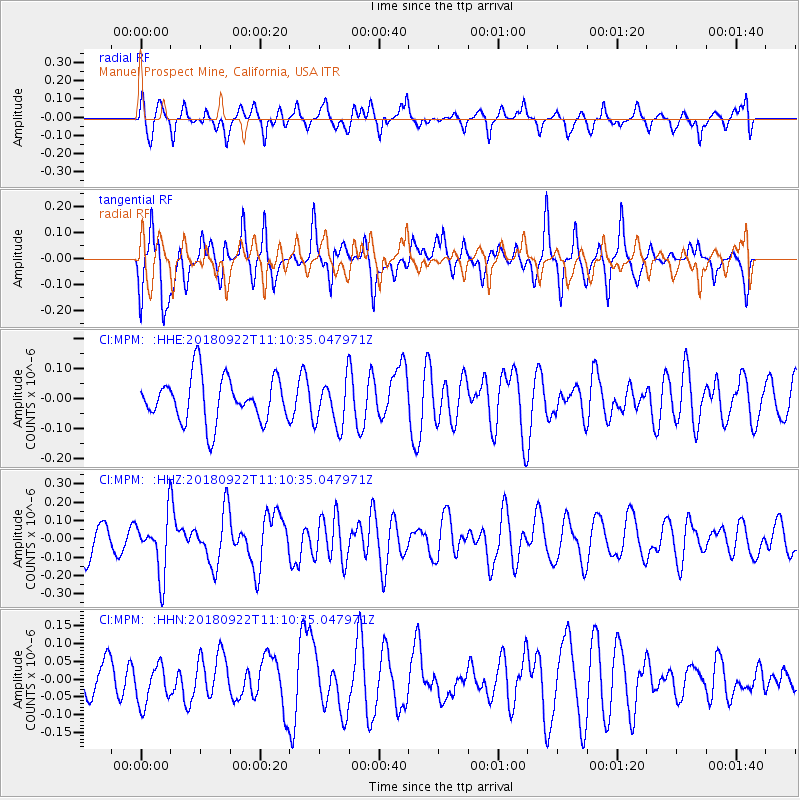
MPM Manuel Prospect Mine, California, USA - Earthquake Result Viewer
*The percent match for this event was below the threshold and hence no stack was calculated.
| Earthquake location: |
Ryukyu Islands, Japan |
| Earthquake latitude/longitude: |
26.7/129.6 |
| Earthquake time(UTC): |
2018/09/22 (265) 10:58:01 GMT |
| Earthquake Depth: |
10 km |
| Earthquake Magnitude: |
5.5 Mww |
| Earthquake Catalog/Contributor: |
NEIC PDE/us |
|
| Network: |
CI Caltech Regional Seismic Network |
| Station: |
MPM Manuel Prospect Mine, California, USA |
| Lat/Lon: |
36.06 N/117.49 W |
| Elevation: |
185 m |
|
| Distance: |
91.2 deg |
| Az: |
48.313 deg |
| Baz: |
304.441 deg |
| Ray Param: |
$rayparam |
*The percent match for this event was below the threshold and hence was not used in the summary stack. |
|
| Radial Match: |
53.942043 % |
| Radial Bump: |
400 |
| Transverse Match: |
68.78514 % |
| Transverse Bump: |
400 |
| SOD ConfigId: |
13570011 |
| Insert Time: |
2019-05-01 07:43:46.373 +0000 |
| GWidth: |
2.5 |
| Max Bumps: |
400 |
| Tol: |
0.001 |
|
Signal To Noise
| Channel | StoN | STA | LTA |
| CI:MPM: :HHZ:20180922T11:10:35.047971Z | 2.0599613 | 1.5861433E-7 | 7.6998695E-8 |
| CI:MPM: :HHN:20180922T11:10:35.047971Z | 1.2363621 | 5.5490137E-8 | 4.4881784E-8 |
| CI:MPM: :HHE:20180922T11:10:35.047971Z | 1.029894 | 7.7125016E-8 | 7.4886366E-8 |
| Arrivals |
| Ps | |
| PpPs | |
| PsPs/PpSs | |


