You are here: Home > Network List > TA - USArray Transportable Network (new EarthScope stations) Stations List
> Station X19A St. Johns, AZ, USA > Earthquake Result Viewer
X19A St. Johns, AZ, USA - Earthquake Result Viewer
| Earthquake location: |
Kuril Islands |
| Earthquake latitude/longitude: |
51.0/157.6 |
| Earthquake time(UTC): |
2008/07/24 (206) 01:43:16 GMT |
| Earthquake Depth: |
27 km |
| Earthquake Magnitude: |
6.0 MB, 6.0 MS, 6.2 MW, 6.2 MW |
| Earthquake Catalog/Contributor: |
WHDF/NEIC |
|
| Network: |
TA USArray Transportable Network (new EarthScope stations) |
| Station: |
X19A St. Johns, AZ, USA |
| Lat/Lon: |
34.43 N/109.29 W |
| Elevation: |
1861 m |
|
| Distance: |
66.0 deg |
| Az: |
64.665 deg |
| Baz: |
316.26 deg |
| Ray Param: |
0.05789583 |
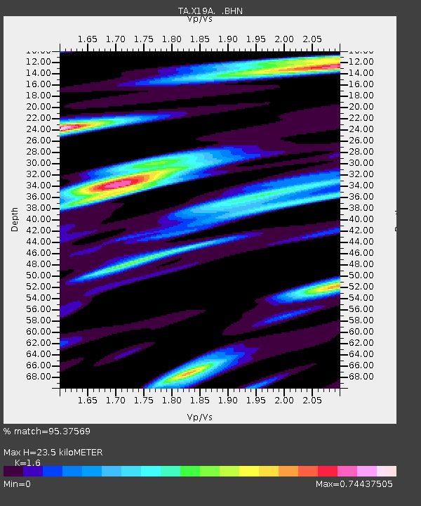
| Estimated Moho Depth: |
23.5 km |
| Estimated Crust Vp/Vs: |
1.60 |
| Assumed Crust Vp: |
6.496 km/s |
| Estimated Crust Vs: |
4.06 km/s |
| Estimated Crust Poisson's Ratio: |
0.18 |
|
| Radial Match: |
95.37569 % |
| Radial Bump: |
321 |
| Transverse Match: |
70.83162 % |
| Transverse Bump: |
400 |
| SOD ConfigId: |
2504 |
| Insert Time: |
2010-03-06 16:09:08.183 +0000 |
| GWidth: |
2.5 |
| Max Bumps: |
400 |
| Tol: |
0.001 |
|
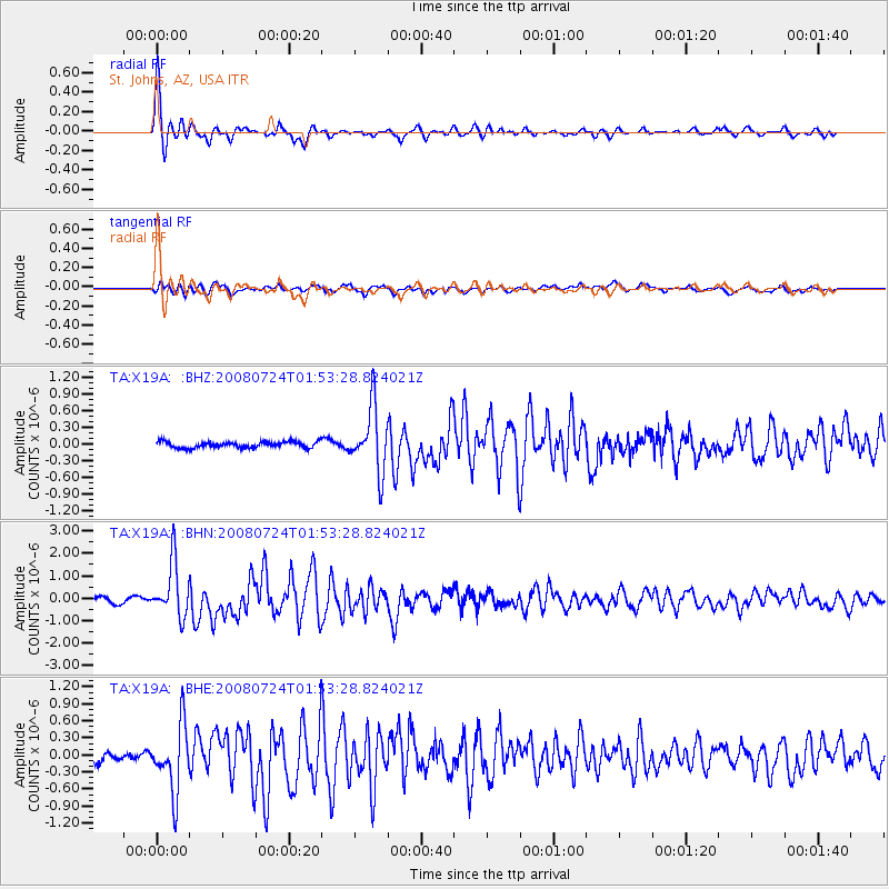
Signal To Noise
| Channel | StoN | STA | LTA |
| TA:X19A: :BHN:20080724T01:53:28.824021Z | 10.200249 | 1.1938785E-6 | 1.1704405E-7 |
| TA:X19A: :BHE:20080724T01:53:28.824021Z | 6.176415 | 5.8166063E-7 | 9.4174474E-8 |
| TA:X19A: :BHZ:20080724T01:53:28.824021Z | 10.441061 | 5.770527E-7 | 5.5267623E-8 |
| Arrivals |
| Ps | 2.3 SECOND |
| PpPs | 9.0 SECOND |
| PsPs/PpSs | 11 SECOND |


