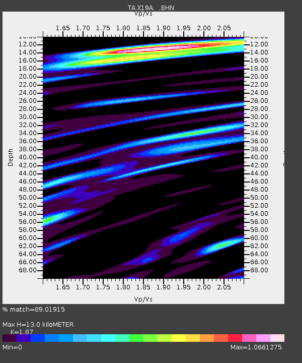
X19A St. Johns, AZ, USA - Earthquake Result Viewer

Earthquake location: Andreanof Islands, Aleutian Is.
Earthquake latitude/longitude: 52.2/-175.7
Earthquake time(UTC): 2008/08/07 (220) 18:30:03 GMT
Earthquake Depth: 12 km
Earthquake Magnitude: 5.6 MB, 5.5 MS, 5.8 MW, 5.8 MW
Earthquake Catalog/Contributor: WHDF/NEIC
Network: TA USArray Transportable Network (new EarthScope stations)
Station: X19A St. Johns, AZ, USA
Lat/Lon: 34.43 N/109.29 W
Elevation: 1861 m
Distance: 49.6 deg
Az: 83.576 deg
Baz: 312.262 deg
Ray Param: 0.068564765
Estimated Moho Depth: 13.0 km
Estimated Crust Vp/Vs: 1.87
Assumed Crust Vp: 6.496 km/s
Estimated Crust Vs: 3.474 km/s
Estimated Crust Poisson's Ratio: 0.30
Radial Match: 89.01915 %
Radial Bump: 320
Transverse Match: 72.76435 %
Transverse Bump: 400
SOD ConfigId: 2504
Insert Time: 2010-03-06 16:09:11.986 +0000
GWidth: 2.5
Max Bumps: 400
Tol: 0.001

Signal To Noise

ChannelStoNSTALTA
TA:X19A: :BHN:20080807T18:38:23.425011Z5.88078263.6785897E-76.255272E-8
TA:X19A: :BHE:20080807T18:38:23.425011Z4.0352392.1527386E-75.3348472E-8
TA:X19A: :BHZ:20080807T18:38:23.425011Z5.7887271.9418238E-73.3544918E-8
Arrivals
Ps1.8 SECOND
PpPs5.4 SECOND
PsPs/PpSs7.3 SECOND