You are here: Home > Network List > TA - USArray Transportable Network (new EarthScope stations) Stations List
> Station D25K Kavik River, AK, USA > Earthquake Result Viewer
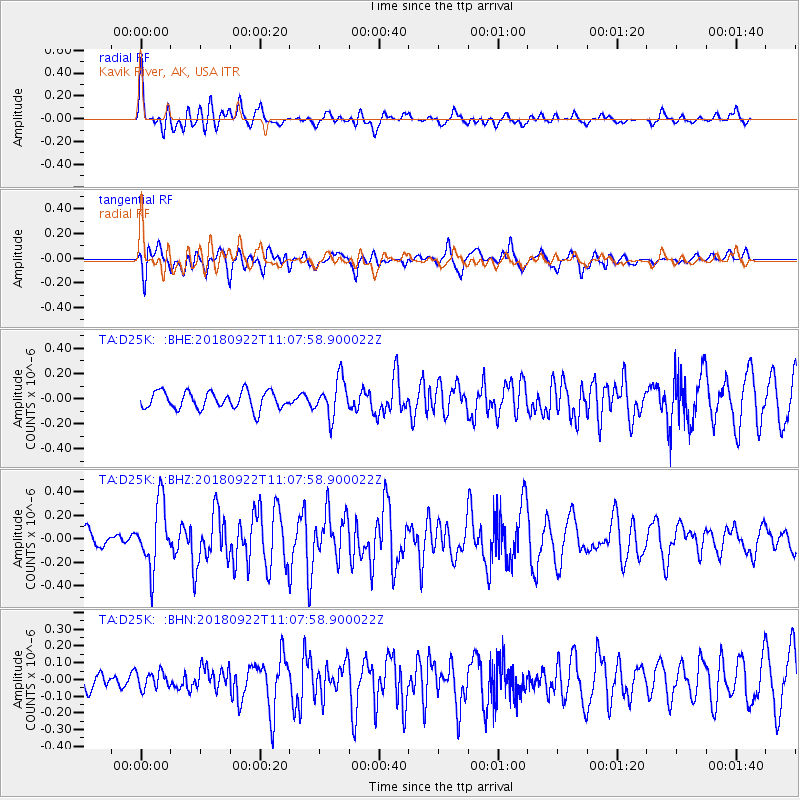
D25K Kavik River, AK, USA - Earthquake Result Viewer
*The percent match for this event was below the threshold and hence no stack was calculated.
| Earthquake location: |
Ryukyu Islands, Japan |
| Earthquake latitude/longitude: |
26.7/129.6 |
| Earthquake time(UTC): |
2018/09/22 (265) 10:58:01 GMT |
| Earthquake Depth: |
10 km |
| Earthquake Magnitude: |
5.5 Mww |
| Earthquake Catalog/Contributor: |
NEIC PDE/us |
|
| Network: |
TA USArray Transportable Network (new EarthScope stations) |
| Station: |
D25K Kavik River, AK, USA |
| Lat/Lon: |
69.32 N/146.38 W |
| Elevation: |
770 m |
|
| Distance: |
63.2 deg |
| Az: |
23.309 deg |
| Baz: |
274.548 deg |
| Ray Param: |
$rayparam |
*The percent match for this event was below the threshold and hence was not used in the summary stack. |
|
| Radial Match: |
76.342476 % |
| Radial Bump: |
400 |
| Transverse Match: |
67.38238 % |
| Transverse Bump: |
400 |
| SOD ConfigId: |
13570011 |
| Insert Time: |
2019-05-01 07:47:14.289 +0000 |
| GWidth: |
2.5 |
| Max Bumps: |
400 |
| Tol: |
0.001 |
|
Signal To Noise
| Channel | StoN | STA | LTA |
| TA:D25K: :BHZ:20180922T11:07:58.900022Z | 3.7023566 | 2.697429E-7 | 7.285709E-8 |
| TA:D25K: :BHN:20180922T11:07:58.900022Z | 0.81104106 | 5.0701917E-8 | 6.2514616E-8 |
| TA:D25K: :BHE:20180922T11:07:58.900022Z | 2.105297 | 1.4612993E-7 | 6.9410596E-8 |
| Arrivals |
| Ps | |
| PpPs | |
| PsPs/PpSs | |


