You are here: Home > Network List > TA - USArray Transportable Network (new EarthScope stations) Stations List
> Station I30M Mount Dempster, Yukon, CAN > Earthquake Result Viewer
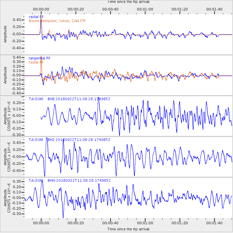
I30M Mount Dempster, Yukon, CAN - Earthquake Result Viewer
*The percent match for this event was below the threshold and hence no stack was calculated.
| Earthquake location: |
Ryukyu Islands, Japan |
| Earthquake latitude/longitude: |
26.7/129.6 |
| Earthquake time(UTC): |
2018/09/22 (265) 10:58:01 GMT |
| Earthquake Depth: |
10 km |
| Earthquake Magnitude: |
5.5 Mww |
| Earthquake Catalog/Contributor: |
NEIC PDE/us |
|
| Network: |
TA USArray Transportable Network (new EarthScope stations) |
| Station: |
I30M Mount Dempster, Yukon, CAN |
| Lat/Lon: |
65.22 N/136.38 W |
| Elevation: |
1399 m |
|
| Distance: |
67.7 deg |
| Az: |
27.015 deg |
| Baz: |
285.31 deg |
| Ray Param: |
$rayparam |
*The percent match for this event was below the threshold and hence was not used in the summary stack. |
|
| Radial Match: |
63.947227 % |
| Radial Bump: |
400 |
| Transverse Match: |
41.497936 % |
| Transverse Bump: |
400 |
| SOD ConfigId: |
13570011 |
| Insert Time: |
2019-05-01 07:47:53.902 +0000 |
| GWidth: |
2.5 |
| Max Bumps: |
400 |
| Tol: |
0.001 |
|
Signal To Noise
| Channel | StoN | STA | LTA |
| TA:I30M: :BHZ:20180922T11:08:28.174985Z | 5.393486 | 2.8315588E-7 | 5.24996E-8 |
| TA:I30M: :BHN:20180922T11:08:28.174985Z | 2.9255598 | 1.570351E-7 | 5.3676942E-8 |
| TA:I30M: :BHE:20180922T11:08:28.174985Z | 1.6032171 | 1.2326964E-7 | 7.6888924E-8 |
| Arrivals |
| Ps | |
| PpPs | |
| PsPs/PpSs | |


