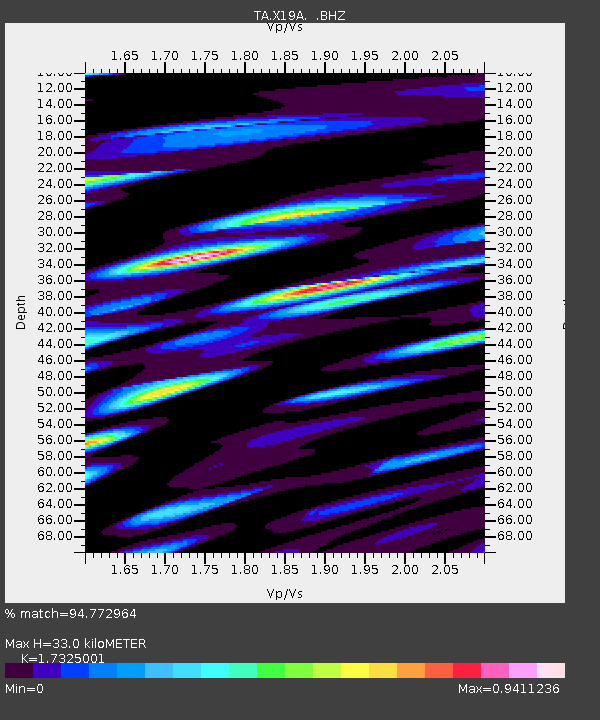
X19A St. Johns, AZ, USA - Earthquake Result Viewer
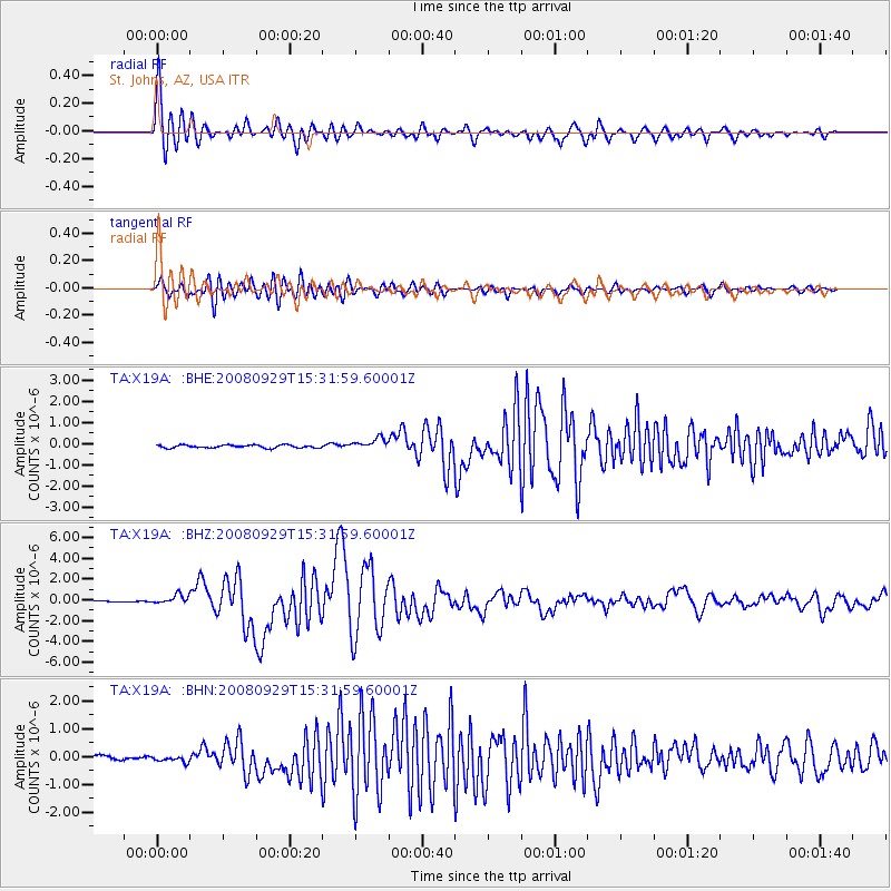
Earthquake location: Kermadec Islands, New Zealand
Earthquake latitude/longitude: -29.8/-177.7
Earthquake time(UTC): 2008/09/29 (273) 15:19:31 GMT
Earthquake Depth: 36 km
Earthquake Magnitude: 6.5 MB, 6.7 MS, 7.0 MW, 7.0 MW
Earthquake Catalog/Contributor: WHDF/NEIC
Network: TA USArray Transportable Network (new EarthScope stations)
Station: X19A St. Johns, AZ, USA
Lat/Lon: 34.43 N/109.29 W
Elevation: 1861 m
Distance: 90.8 deg
Az: 50.227 deg
Baz: 233.954 deg
Ray Param: 0.041646067
Estimated Moho Depth: 33.0 km
Estimated Crust Vp/Vs: 1.73
Assumed Crust Vp: 6.496 km/s
Estimated Crust Vs: 3.75 km/s
Estimated Crust Poisson's Ratio: 0.25
Radial Match: 94.772964 %
Radial Bump: 400
Transverse Match: 85.61481 %
Transverse Bump: 400
SOD ConfigId: 2560
Insert Time: 2010-03-06 16:09:40.229 +0000
GWidth: 2.5
Max Bumps: 400
Tol: 0.001

Signal To Noise

ChannelStoNSTALTA
TA:X19A: :BHZ:20080929T15:31:59.60001Z5.9420384.2955253E-77.229043E-8
TA:X19A: :BHN:20080929T15:31:59.60001Z1.54140951.1800902E-77.655917E-8
TA:X19A: :BHE:20080929T15:31:59.60001Z3.92562372.6900523E-76.852547E-8
Arrivals
Ps3.8 SECOND
PpPs14 SECOND
PsPs/PpSs17 SECOND