You are here: Home > Network List > TA - USArray Transportable Network (new EarthScope stations) Stations List
> Station P17K Kvichak River, AK, USA > Earthquake Result Viewer
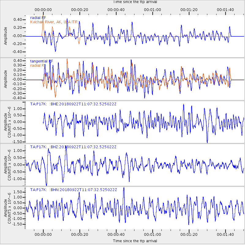
P17K Kvichak River, AK, USA - Earthquake Result Viewer
*The percent match for this event was below the threshold and hence no stack was calculated.
| Earthquake location: |
Ryukyu Islands, Japan |
| Earthquake latitude/longitude: |
26.7/129.6 |
| Earthquake time(UTC): |
2018/09/22 (265) 10:58:01 GMT |
| Earthquake Depth: |
10 km |
| Earthquake Magnitude: |
5.5 Mww |
| Earthquake Catalog/Contributor: |
NEIC PDE/us |
|
| Network: |
TA USArray Transportable Network (new EarthScope stations) |
| Station: |
P17K Kvichak River, AK, USA |
| Lat/Lon: |
59.20 N/156.44 W |
| Elevation: |
91 m |
|
| Distance: |
59.3 deg |
| Az: |
35.101 deg |
| Baz: |
271.141 deg |
| Ray Param: |
$rayparam |
*The percent match for this event was below the threshold and hence was not used in the summary stack. |
|
| Radial Match: |
56.930473 % |
| Radial Bump: |
400 |
| Transverse Match: |
51.48358 % |
| Transverse Bump: |
400 |
| SOD ConfigId: |
13570011 |
| Insert Time: |
2019-05-01 07:48:17.354 +0000 |
| GWidth: |
2.5 |
| Max Bumps: |
400 |
| Tol: |
0.001 |
|
Signal To Noise
| Channel | StoN | STA | LTA |
| TA:P17K: :BHZ:20180922T11:07:32.525022Z | 4.1492524 | 7.3332825E-7 | 1.7673746E-7 |
| TA:P17K: :BHN:20180922T11:07:32.525022Z | 1.0581731 | 5.04269E-7 | 4.765468E-7 |
| TA:P17K: :BHE:20180922T11:07:32.525022Z | 0.91528803 | 3.85496E-7 | 4.2117452E-7 |
| Arrivals |
| Ps | |
| PpPs | |
| PsPs/PpSs | |


