You are here: Home > Network List > TA - USArray Transportable Network (new EarthScope stations) Stations List
> Station X19A St. Johns, AZ, USA > Earthquake Result Viewer
X19A St. Johns, AZ, USA - Earthquake Result Viewer
| Earthquake location: |
Kermadec Islands Region |
| Earthquake latitude/longitude: |
-31.2/-176.9 |
| Earthquake time(UTC): |
2008/12/09 (344) 06:23:59 GMT |
| Earthquake Depth: |
18 km |
| Earthquake Magnitude: |
6.2 MB, 6.7 MS, 6.8 MW, 6.7 MW |
| Earthquake Catalog/Contributor: |
WHDF/NEIC |
|
| Network: |
TA USArray Transportable Network (new EarthScope stations) |
| Station: |
X19A St. Johns, AZ, USA |
| Lat/Lon: |
34.43 N/109.29 W |
| Elevation: |
1861 m |
|
| Distance: |
91.2 deg |
| Az: |
49.871 deg |
| Baz: |
232.405 deg |
| Ray Param: |
0.041617792 |
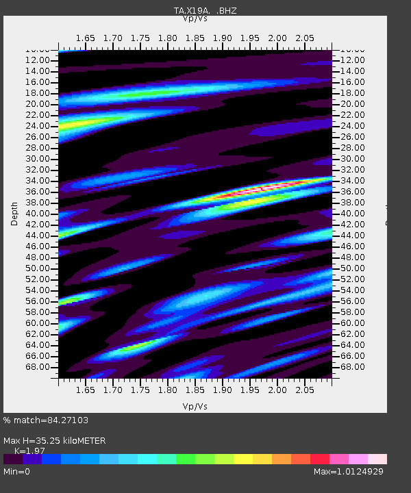
| Estimated Moho Depth: |
35.25 km |
| Estimated Crust Vp/Vs: |
1.97 |
| Assumed Crust Vp: |
6.496 km/s |
| Estimated Crust Vs: |
3.297 km/s |
| Estimated Crust Poisson's Ratio: |
0.33 |
|
| Radial Match: |
84.27103 % |
| Radial Bump: |
400 |
| Transverse Match: |
74.30592 % |
| Transverse Bump: |
400 |
| SOD ConfigId: |
2658 |
| Insert Time: |
2010-03-06 16:09:54.541 +0000 |
| GWidth: |
2.5 |
| Max Bumps: |
400 |
| Tol: |
0.001 |
|
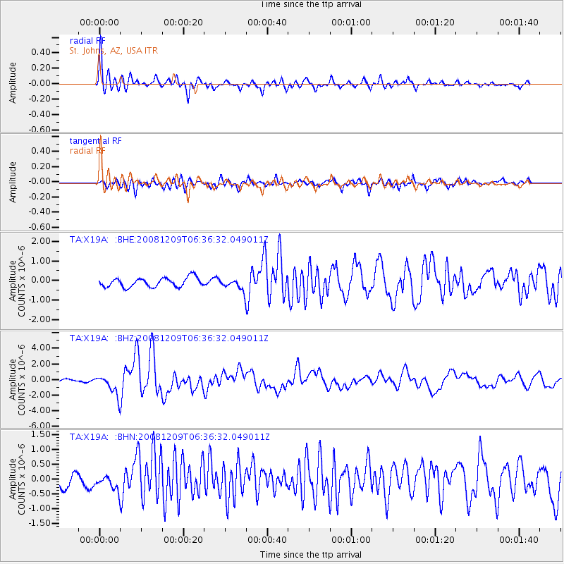
Signal To Noise
| Channel | StoN | STA | LTA |
| TA:X19A: :BHZ:20081209T06:36:32.049011Z | 4.7211633 | 1.347902E-6 | 2.855021E-7 |
| TA:X19A: :BHN:20081209T06:36:32.049011Z | 0.9745339 | 2.6299318E-7 | 2.698656E-7 |
| TA:X19A: :BHE:20081209T06:36:32.049011Z | 1.3381922 | 3.1233677E-7 | 2.3340202E-7 |
| Arrivals |
| Ps | 5.4 SECOND |
| PpPs | 16 SECOND |
| PsPs/PpSs | 21 SECOND |


