You are here: Home > Network List > TA - USArray Transportable Network (new EarthScope stations) Stations List
> Station X19A St. Johns, AZ, USA > Earthquake Result Viewer
X19A St. Johns, AZ, USA - Earthquake Result Viewer

| Earthquake location: |
Northern Mid-Atlantic Ridge |
| Earthquake latitude/longitude: |
47.0/-27.3 |
| Earthquake time(UTC): |
2008/12/19 (354) 08:31:51 GMT |
| Earthquake Depth: |
2.0 km |
| Earthquake Magnitude: |
5.8 MB, 5.6 MS, 5.9 MW, 5.8 MW |
| Earthquake Catalog/Contributor: |
WHDF/NEIC |
|
| Network: |
TA USArray Transportable Network (new EarthScope stations) |
| Station: |
X19A St. Johns, AZ, USA |
| Lat/Lon: |
34.43 N/109.29 W |
| Elevation: |
1861 m |
|
| Distance: |
60.7 deg |
| Az: |
290.209 deg |
| Baz: |
50.989 deg |
| Ray Param: |
0.061362352 |
| Estimated Moho Depth: |
12.25 km |
| Estimated Crust Vp/Vs: |
2.10 |
| Assumed Crust Vp: |
6.496 km/s |
| Estimated Crust Vs: |
3.097 km/s |
| Estimated Crust Poisson's Ratio: |
0.35 |
|
| Radial Match: |
84.67297 % |
| Radial Bump: |
377 |
| Transverse Match: |
72.03392 % |
| Transverse Bump: |
400 |
| SOD ConfigId: |
2658 |
| Insert Time: |
2010-03-06 16:09:56.543 +0000 |
| GWidth: |
2.5 |
| Max Bumps: |
400 |
| Tol: |
0.001 |
|
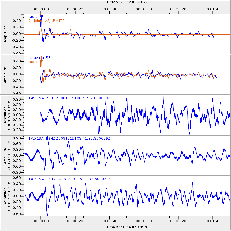
Signal To Noise
| Channel | StoN | STA | LTA |
| TA:X19A: :BHZ:20081219T08:41:32.800029Z | 4.772274 | 5.1839095E-7 | 1.0862557E-7 |
| TA:X19A: :BHN:20081219T08:41:32.800029Z | 2.3671563 | 2.5903356E-7 | 1.09428164E-7 |
| TA:X19A: :BHE:20081219T08:41:32.800029Z | 1.9615806 | 1.6102442E-7 | 8.2089116E-8 |
| Arrivals |
| Ps | 2.2 SECOND |
| PpPs | 5.6 SECOND |
| PsPs/PpSs | 7.8 SECOND |


