You are here: Home > Network List > II - Global Seismograph Network (GSN - IRIS/IDA) Stations List
> Station WRAB Tennant Creek, NT, Australia > Earthquake Result Viewer
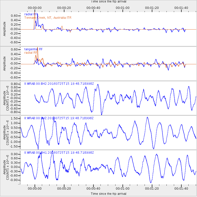
WRAB Tennant Creek, NT, Australia - Earthquake Result Viewer
*The percent match for this event was below the threshold and hence no stack was calculated.
| Earthquake location: |
Ryukyu Islands, Japan |
| Earthquake latitude/longitude: |
26.5/128.7 |
| Earthquake time(UTC): |
2016/07/25 (207) 15:11:53 GMT |
| Earthquake Depth: |
14 km |
| Earthquake Magnitude: |
5.5 MB, 5.3 MWB |
| Earthquake Catalog/Contributor: |
NEIC PDE/NEIC COMCAT |
|
| Network: |
II Global Seismograph Network (GSN - IRIS/IDA) |
| Station: |
WRAB Tennant Creek, NT, Australia |
| Lat/Lon: |
19.93 S/134.36 E |
| Elevation: |
366 m |
|
| Distance: |
46.5 deg |
| Az: |
172.693 deg |
| Baz: |
353.04 deg |
| Ray Param: |
$rayparam |
*The percent match for this event was below the threshold and hence was not used in the summary stack. |
|
| Radial Match: |
88.65187 % |
| Radial Bump: |
400 |
| Transverse Match: |
59.72267 % |
| Transverse Bump: |
400 |
| SOD ConfigId: |
1634031 |
| Insert Time: |
2016-08-08 15:13:58.675 +0000 |
| GWidth: |
2.5 |
| Max Bumps: |
400 |
| Tol: |
0.001 |
|
Signal To Noise
| Channel | StoN | STA | LTA |
| II:WRAB:00:BHZ:20160725T15:19:48.718998Z | 2.7074902 | 9.434843E-7 | 3.484719E-7 |
| II:WRAB:00:BH1:20160725T15:19:48.718998Z | 2.6202848 | 6.9201536E-7 | 2.640993E-7 |
| II:WRAB:00:BH2:20160725T15:19:48.718998Z | 1.2180444 | 2.911694E-7 | 2.3904664E-7 |
| Arrivals |
| Ps | |
| PpPs | |
| PsPs/PpSs | |


