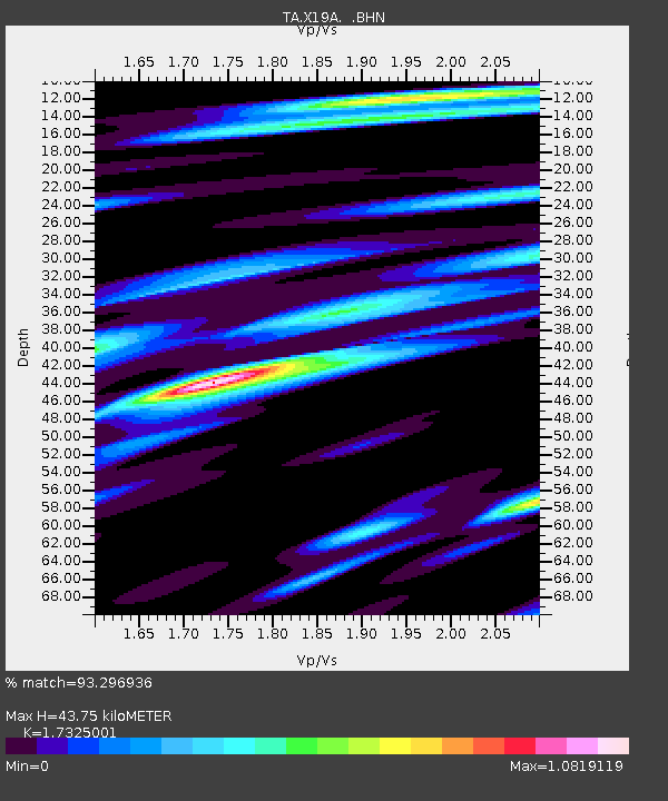
X19A St. Johns, AZ, USA - Earthquake Result Viewer
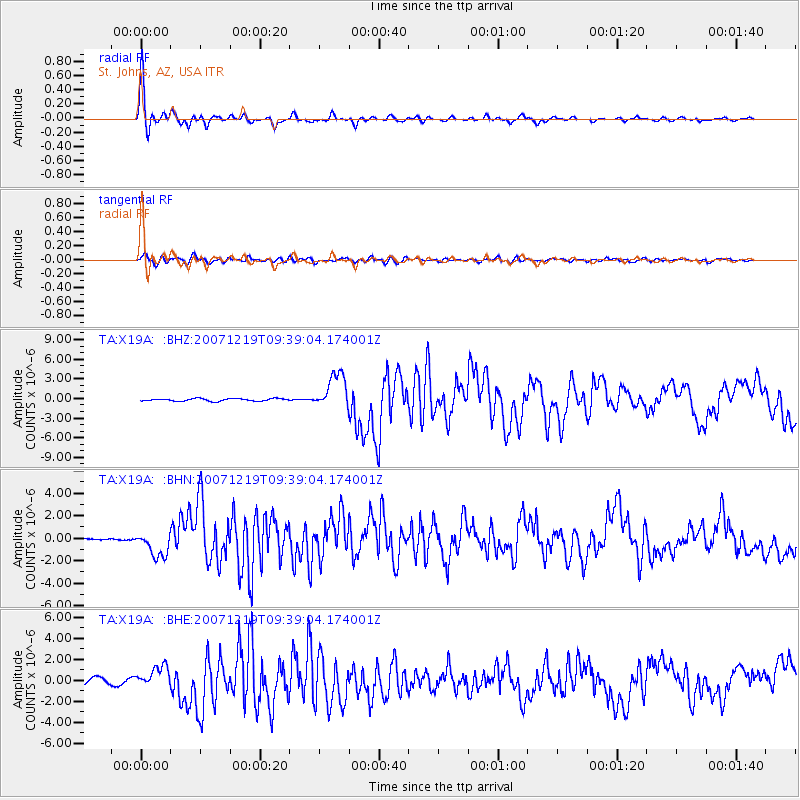
Earthquake location: Andreanof Islands, Aleutian Is.
Earthquake latitude/longitude: 51.4/-179.5
Earthquake time(UTC): 2007/12/19 (353) 09:30:27 GMT
Earthquake Depth: 29 km
Earthquake Magnitude: 6.4 MB, 7.1 MS, 7.1 MW, 7.0 MW
Earthquake Catalog/Contributor: WHDF/NEIC
Network: TA USArray Transportable Network (new EarthScope stations)
Station: X19A St. Johns, AZ, USA
Lat/Lon: 34.43 N/109.29 W
Elevation: 1861 m
Distance: 52.1 deg
Az: 80.153 deg
Baz: 311.645 deg
Ray Param: 0.06689861
Estimated Moho Depth: 43.75 km
Estimated Crust Vp/Vs: 1.73
Assumed Crust Vp: 6.496 km/s
Estimated Crust Vs: 3.75 km/s
Estimated Crust Poisson's Ratio: 0.25
Radial Match: 93.296936 %
Radial Bump: 395
Transverse Match: 77.340706 %
Transverse Bump: 400
SOD ConfigId: 2564
Insert Time: 2010-03-06 16:10:05.912 +0000
GWidth: 2.5
Max Bumps: 400
Tol: 0.001

Signal To Noise

ChannelStoNSTALTA
TA:X19A: :BHN:20071219T09:39:04.174001Z14.2679821.1512944E-68.0690775E-8
TA:X19A: :BHE:20071219T09:39:04.174001Z3.3811371.0274119E-63.0386582E-7
TA:X19A: :BHZ:20071219T09:39:04.174001Z14.2376722.7085937E-61.9024134E-7
Arrivals
Ps5.2 SECOND
PpPs17 SECOND
PsPs/PpSs23 SECOND