You are here: Home > Network List > TA - USArray Transportable Network (new EarthScope stations) Stations List
> Station X19A St. Johns, AZ, USA > Earthquake Result Viewer
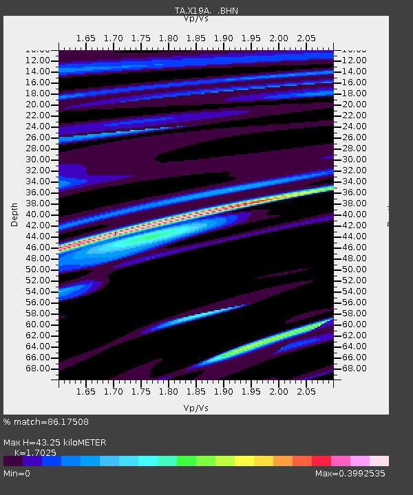
X19A St. Johns, AZ, USA - Earthquake Result Viewer
| Earthquake location: |
Solomon Islands |
| Earthquake latitude/longitude: |
-10.9/162.1 |
| Earthquake time(UTC): |
2007/11/27 (331) 11:49:58 GMT |
| Earthquake Depth: |
16 km |
| Earthquake Magnitude: |
5.9 MB, 6.7 MS, 6.6 MW, 6.4 MW |
| Earthquake Catalog/Contributor: |
WHDF/NEIC |
|
| Network: |
TA USArray Transportable Network (new EarthScope stations) |
| Station: |
X19A St. Johns, AZ, USA |
| Lat/Lon: |
34.43 N/109.29 W |
| Elevation: |
1861 m |
|
| Distance: |
94.9 deg |
| Az: |
56.038 deg |
| Baz: |
260.182 deg |
| Ray Param: |
0.040915474 |
| Estimated Moho Depth: |
43.25 km |
| Estimated Crust Vp/Vs: |
1.70 |
| Assumed Crust Vp: |
6.496 km/s |
| Estimated Crust Vs: |
3.816 km/s |
| Estimated Crust Poisson's Ratio: |
0.24 |
|
| Radial Match: |
86.17508 % |
| Radial Bump: |
313 |
| Transverse Match: |
57.129642 % |
| Transverse Bump: |
400 |
| SOD ConfigId: |
2564 |
| Insert Time: |
2010-03-06 16:10:08.816 +0000 |
| GWidth: |
2.5 |
| Max Bumps: |
400 |
| Tol: |
0.001 |
|

Signal To Noise
| Channel | StoN | STA | LTA |
| TA:X19A: :BHN:20071127T12:02:47.674001Z | 0.33901182 | 5.161246E-8 | 1.5224384E-7 |
| TA:X19A: :BHE:20071127T12:02:47.674001Z | 2.629664 | 1.5251103E-7 | 5.7996395E-8 |
| TA:X19A: :BHZ:20071127T12:02:47.674001Z | 13.331464 | 5.744941E-7 | 4.30931E-8 |
| Arrivals |
| Ps | 4.8 SECOND |
| PpPs | 18 SECOND |
| PsPs/PpSs | 22 SECOND |


