You are here: Home > Network List > TA - USArray Transportable Network (new EarthScope stations) Stations List
> Station X19A St. Johns, AZ, USA > Earthquake Result Viewer
X19A St. Johns, AZ, USA - Earthquake Result Viewer
| Earthquake location: |
Kermadec Islands, New Zealand |
| Earthquake latitude/longitude: |
-30.0/-177.9 |
| Earthquake time(UTC): |
2007/11/20 (324) 15:28:28 GMT |
| Earthquake Depth: |
59 km |
| Earthquake Magnitude: |
6.0 MB, 5.9 MW, 5.8 MW |
| Earthquake Catalog/Contributor: |
WHDF/NEIC |
|
| Network: |
TA USArray Transportable Network (new EarthScope stations) |
| Station: |
X19A St. Johns, AZ, USA |
| Lat/Lon: |
34.43 N/109.29 W |
| Elevation: |
1861 m |
|
| Distance: |
91.1 deg |
| Az: |
50.35 deg |
| Baz: |
233.877 deg |
| Ray Param: |
0.04161654 |
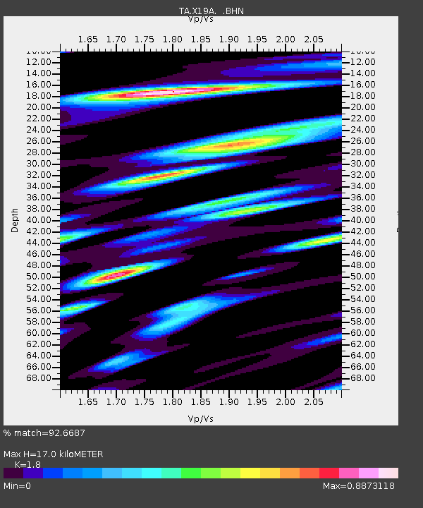
| Estimated Moho Depth: |
17.0 km |
| Estimated Crust Vp/Vs: |
1.80 |
| Assumed Crust Vp: |
6.496 km/s |
| Estimated Crust Vs: |
3.609 km/s |
| Estimated Crust Poisson's Ratio: |
0.28 |
|
| Radial Match: |
92.6687 % |
| Radial Bump: |
400 |
| Transverse Match: |
79.92957 % |
| Transverse Bump: |
400 |
| SOD ConfigId: |
2564 |
| Insert Time: |
2010-03-06 16:10:10.797 +0000 |
| GWidth: |
2.5 |
| Max Bumps: |
400 |
| Tol: |
0.001 |
|
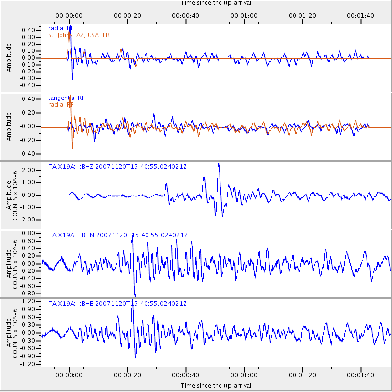
Signal To Noise
| Channel | StoN | STA | LTA |
| TA:X19A: :BHN:20071120T15:40:55.024021Z | 1.3332547 | 1.3550299E-7 | 1.0163324E-7 |
| TA:X19A: :BHE:20071120T15:40:55.024021Z | 2.234632 | 1.645825E-7 | 7.365083E-8 |
| TA:X19A: :BHZ:20071120T15:40:55.024021Z | 3.2944443 | 3.7937724E-7 | 1.15156666E-7 |
| Arrivals |
| Ps | 2.1 SECOND |
| PpPs | 7.2 SECOND |
| PsPs/PpSs | 9.3 SECOND |


