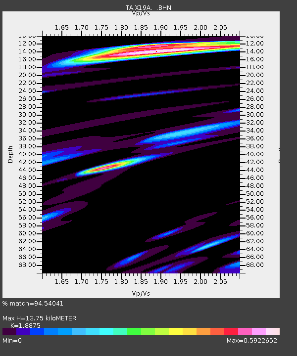
X19A St. Johns, AZ, USA - Earthquake Result Viewer
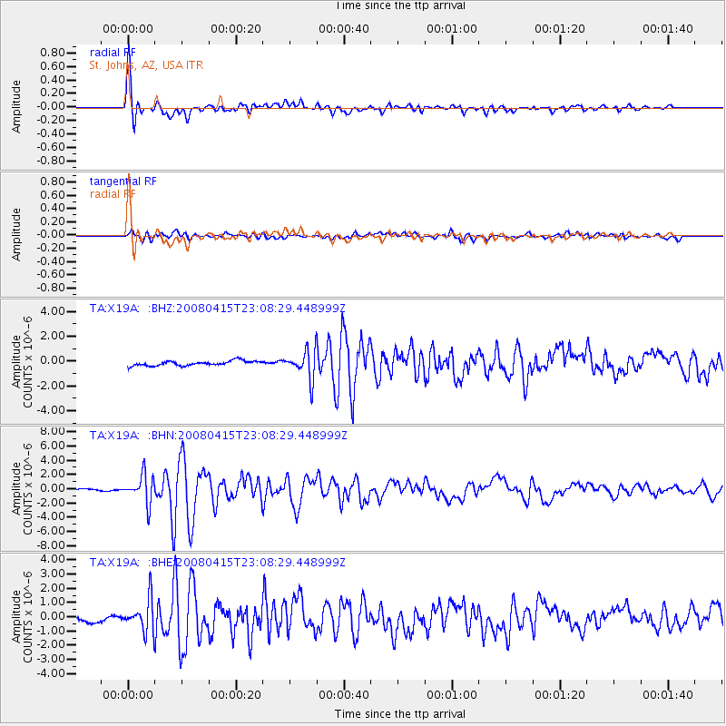
Earthquake location: Andreanof Islands, Aleutian Is.
Earthquake latitude/longitude: 51.9/-179.4
Earthquake time(UTC): 2008/04/15 (106) 22:59:51 GMT
Earthquake Depth: 10 km
Earthquake Magnitude: 6.1 MB, 6.4 MS, 6.4 MW, 6.4 MW
Earthquake Catalog/Contributor: WHDF/NEIC
Network: TA USArray Transportable Network (new EarthScope stations)
Station: X19A St. Johns, AZ, USA
Lat/Lon: 34.43 N/109.29 W
Elevation: 1861 m
Distance: 52.0 deg
Az: 80.646 deg
Baz: 312.238 deg
Ray Param: 0.06707056
Estimated Moho Depth: 13.75 km
Estimated Crust Vp/Vs: 1.89
Assumed Crust Vp: 6.496 km/s
Estimated Crust Vs: 3.442 km/s
Estimated Crust Poisson's Ratio: 0.30
Radial Match: 94.54041 %
Radial Bump: 400
Transverse Match: 84.70719 %
Transverse Bump: 400
SOD ConfigId: 2504
Insert Time: 2010-03-06 16:11:07.260 +0000
GWidth: 2.5
Max Bumps: 400
Tol: 0.001

Signal To Noise

ChannelStoNSTALTA
TA:X19A: :BHN:20080415T23:08:29.448999Z18.0006481.9726892E-61.095899E-7
TA:X19A: :BHE:20080415T23:08:29.448999Z7.3021341.144406E-61.5672212E-7
TA:X19A: :BHZ:20080415T23:08:29.448999Z6.06995341.1637104E-61.9171654E-7
Arrivals
Ps2.0 SECOND
PpPs5.8 SECOND
PsPs/PpSs7.8 SECOND