X19A St. Johns, AZ, USA - Earthquake Result Viewer
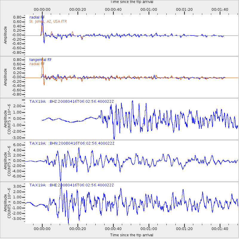
Earthquake location: Andreanof Islands, Aleutian Is.
Earthquake latitude/longitude: 51.9/-179.2
Earthquake time(UTC): 2008/04/16 (107) 05:54:19 GMT
Earthquake Depth: 13 km
Earthquake Magnitude: 6.1 MB, 6.5 MS, 6.6 MW, 6.6 MW
Earthquake Catalog/Contributor: WHDF/NEIC
Network: TA USArray Transportable Network (new EarthScope stations)
Station: X19A St. Johns, AZ, USA
Lat/Lon: 34.43 N/109.29 W
Elevation: 1861 m
Distance: 51.8 deg
Az: 80.801 deg
Baz: 312.244 deg
Ray Param: 0.06714406
Estimated Moho Depth: 13.0 km
Estimated Crust Vp/Vs: 1.90
Assumed Crust Vp: 6.496 km/s
Estimated Crust Vs: 3.41 km/s
Estimated Crust Poisson's Ratio: 0.31
Radial Match: 92.51384 %
Radial Bump: 400
Transverse Match: 87.37563 %
Transverse Bump: 400
SOD ConfigId: 2504
Insert Time: 2010-03-06 16:11:08.937 +0000
GWidth: 2.5
Max Bumps: 400
Tol: 0.001

Signal To Noise

ChannelStoNSTALTA
TA:X19A: :BHN:20080416T06:02:56.400022Z9.2790987.2326145E-77.794524E-8
TA:X19A: :BHE:20080416T06:02:56.400022Z4.2819926.6672783E-71.5570508E-7
TA:X19A: :BHZ:20080416T06:02:56.400022Z3.17653946.2449095E-71.9659474E-7
Arrivals
Ps1.9 SECOND
PpPs5.5 SECOND
PsPs/PpSs7.4 SECOND