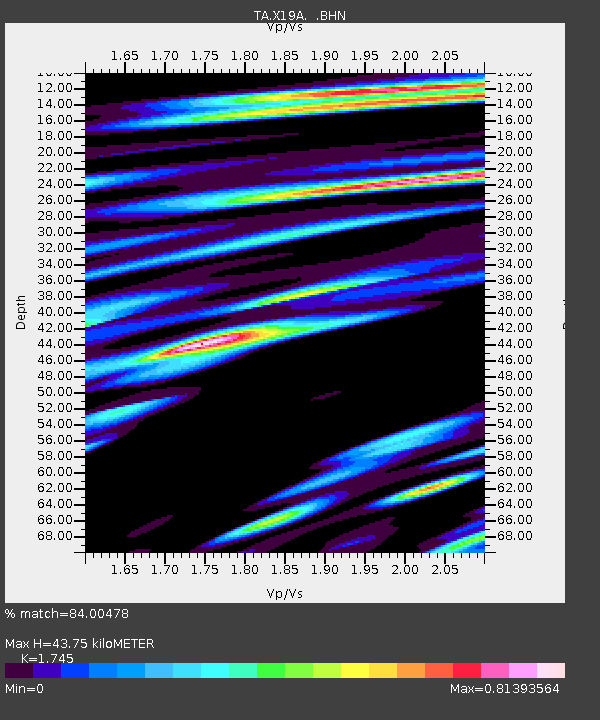
X19A St. Johns, AZ, USA - Earthquake Result Viewer
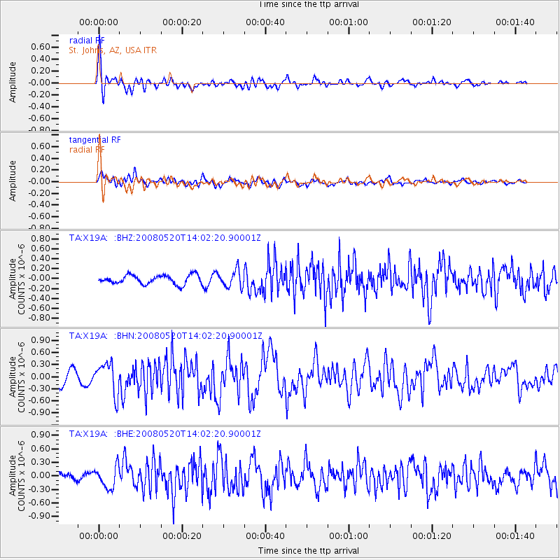
Earthquake location: Rat Islands, Aleutian Islands
Earthquake latitude/longitude: 51.2/178.8
Earthquake time(UTC): 2008/05/20 (141) 13:53:35 GMT
Earthquake Depth: 27 km
Earthquake Magnitude: 5.8 MB, 6.0 MS, 6.3 MW, 6.3 MW
Earthquake Catalog/Contributor: WHDF/NEIC
Network: TA USArray Transportable Network (new EarthScope stations)
Station: X19A St. Johns, AZ, USA
Lat/Lon: 34.43 N/109.29 W
Elevation: 1861 m
Distance: 53.2 deg
Az: 78.815 deg
Baz: 311.644 deg
Ray Param: 0.06618737
Estimated Moho Depth: 43.75 km
Estimated Crust Vp/Vs: 1.75
Assumed Crust Vp: 6.496 km/s
Estimated Crust Vs: 3.723 km/s
Estimated Crust Poisson's Ratio: 0.26
Radial Match: 84.00478 %
Radial Bump: 400
Transverse Match: 77.5811 %
Transverse Bump: 400
SOD ConfigId: 2504
Insert Time: 2010-03-06 16:11:15.815 +0000
GWidth: 2.5
Max Bumps: 400
Tol: 0.001

Signal To Noise

ChannelStoNSTALTA
TA:X19A: :BHN:20080520T14:02:20.90001Z3.12556823.9843468E-71.2747593E-7
TA:X19A: :BHE:20080520T14:02:20.90001Z3.58903152.4433285E-76.8077654E-8
TA:X19A: :BHZ:20080520T14:02:20.90001Z1.89701591.7128956E-79.0294215E-8
Arrivals
Ps5.3 SECOND
PpPs17 SECOND
PsPs/PpSs23 SECOND