You are here: Home > Network List > TA - USArray Transportable Network (new EarthScope stations) Stations List
> Station X19A St. Johns, AZ, USA > Earthquake Result Viewer
X19A St. Johns, AZ, USA - Earthquake Result Viewer
| Earthquake location: |
Iceland |
| Earthquake latitude/longitude: |
64.0/-21.0 |
| Earthquake time(UTC): |
2008/05/29 (150) 15:46:00 GMT |
| Earthquake Depth: |
10 km |
| Earthquake Magnitude: |
6.0 MB, 6.2 MS, 6.3 MW, 6.2 MW |
| Earthquake Catalog/Contributor: |
WHDF/NEIC |
|
| Network: |
TA USArray Transportable Network (new EarthScope stations) |
| Station: |
X19A St. Johns, AZ, USA |
| Lat/Lon: |
34.43 N/109.29 W |
| Elevation: |
1861 m |
|
| Distance: |
58.9 deg |
| Az: |
285.28 deg |
| Baz: |
30.95 deg |
| Ray Param: |
0.06252569 |
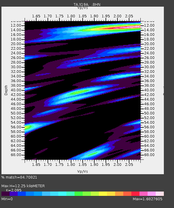
| Estimated Moho Depth: |
12.25 km |
| Estimated Crust Vp/Vs: |
2.10 |
| Assumed Crust Vp: |
6.496 km/s |
| Estimated Crust Vs: |
3.101 km/s |
| Estimated Crust Poisson's Ratio: |
0.35 |
|
| Radial Match: |
84.70821 % |
| Radial Bump: |
396 |
| Transverse Match: |
75.05448 % |
| Transverse Bump: |
400 |
| SOD ConfigId: |
2504 |
| Insert Time: |
2010-03-06 16:11:19.960 +0000 |
| GWidth: |
2.5 |
| Max Bumps: |
400 |
| Tol: |
0.001 |
|
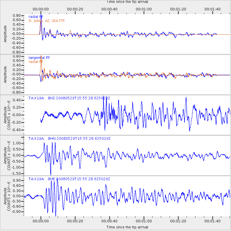
Signal To Noise
| Channel | StoN | STA | LTA |
| TA:X19A: :BHN:20080529T15:55:28.625029Z | 5.5071726 | 4.383438E-7 | 7.959507E-8 |
| TA:X19A: :BHE:20080529T15:55:28.625029Z | 4.0339646 | 3.6968348E-7 | 9.164272E-8 |
| TA:X19A: :BHZ:20080529T15:55:28.625029Z | 1.7713753 | 1.11605466E-7 | 6.300498E-8 |
| Arrivals |
| Ps | 2.2 SECOND |
| PpPs | 5.6 SECOND |
| PsPs/PpSs | 7.8 SECOND |


