You are here: Home > Network List > CI - Caltech Regional Seismic Network Stations List
> Station MPM Manuel Prospect Mine, California, USA > Earthquake Result Viewer
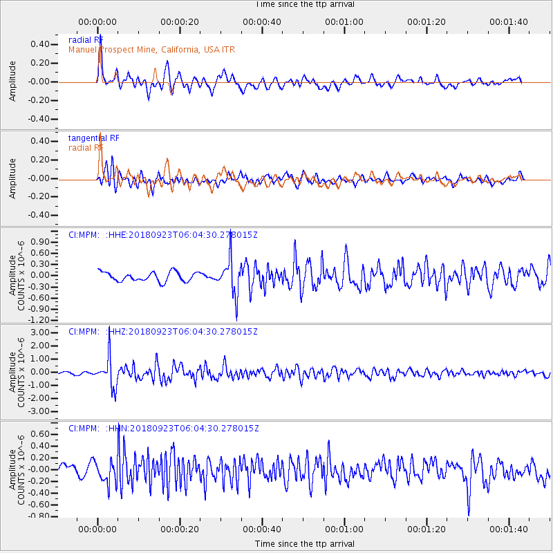
MPM Manuel Prospect Mine, California, USA - Earthquake Result Viewer
*The percent match for this event was below the threshold and hence no stack was calculated.
| Earthquake location: |
South Of Mariana Islands |
| Earthquake latitude/longitude: |
12.2/146.2 |
| Earthquake time(UTC): |
2018/09/23 (266) 05:52:11 GMT |
| Earthquake Depth: |
10 km |
| Earthquake Magnitude: |
5.9 Mww |
| Earthquake Catalog/Contributor: |
NEIC PDE/us |
|
| Network: |
CI Caltech Regional Seismic Network |
| Station: |
MPM Manuel Prospect Mine, California, USA |
| Lat/Lon: |
36.06 N/117.49 W |
| Elevation: |
185 m |
|
| Distance: |
87.9 deg |
| Az: |
53.707 deg |
| Baz: |
283.478 deg |
| Ray Param: |
$rayparam |
*The percent match for this event was below the threshold and hence was not used in the summary stack. |
|
| Radial Match: |
75.84062 % |
| Radial Bump: |
400 |
| Transverse Match: |
73.19111 % |
| Transverse Bump: |
400 |
| SOD ConfigId: |
13570011 |
| Insert Time: |
2019-05-01 08:01:50.369 +0000 |
| GWidth: |
2.5 |
| Max Bumps: |
400 |
| Tol: |
0.001 |
|
Signal To Noise
| Channel | StoN | STA | LTA |
| CI:MPM: :HHZ:20180923T06:04:30.278015Z | 8.38113 | 1.1590325E-6 | 1.3829073E-7 |
| CI:MPM: :HHN:20180923T06:04:30.278015Z | 1.5975108 | 1.946616E-7 | 1.2185306E-7 |
| CI:MPM: :HHE:20180923T06:04:30.278015Z | 3.8355 | 4.7737177E-7 | 1.2446141E-7 |
| Arrivals |
| Ps | |
| PpPs | |
| PsPs/PpSs | |


