You are here: Home > Network List > TA - USArray Transportable Network (new EarthScope stations) Stations List
> Station E20K Nigu River, AK, USA > Earthquake Result Viewer
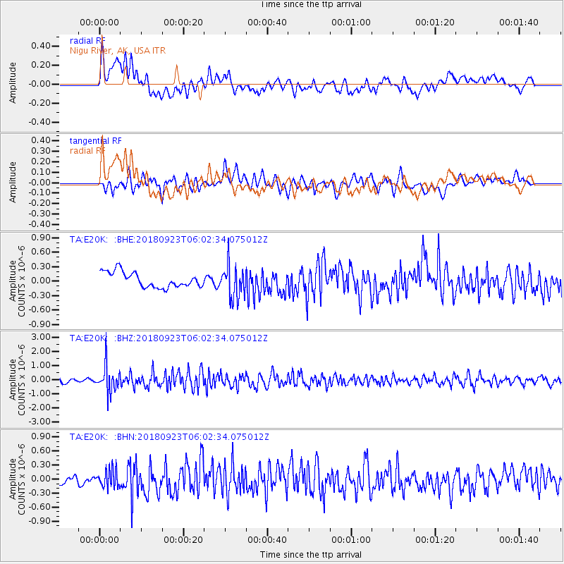
E20K Nigu River, AK, USA - Earthquake Result Viewer
*The percent match for this event was below the threshold and hence no stack was calculated.
| Earthquake location: |
South Of Mariana Islands |
| Earthquake latitude/longitude: |
12.2/146.2 |
| Earthquake time(UTC): |
2018/09/23 (266) 05:52:11 GMT |
| Earthquake Depth: |
10 km |
| Earthquake Magnitude: |
5.9 Mww |
| Earthquake Catalog/Contributor: |
NEIC PDE/us |
|
| Network: |
TA USArray Transportable Network (new EarthScope stations) |
| Station: |
E20K Nigu River, AK, USA |
| Lat/Lon: |
68.26 N/156.19 W |
| Elevation: |
866 m |
|
| Distance: |
67.0 deg |
| Az: |
19.974 deg |
| Baz: |
243.678 deg |
| Ray Param: |
$rayparam |
*The percent match for this event was below the threshold and hence was not used in the summary stack. |
|
| Radial Match: |
62.26684 % |
| Radial Bump: |
400 |
| Transverse Match: |
64.093285 % |
| Transverse Bump: |
400 |
| SOD ConfigId: |
13570011 |
| Insert Time: |
2019-05-01 08:06:15.644 +0000 |
| GWidth: |
2.5 |
| Max Bumps: |
400 |
| Tol: |
0.001 |
|
Signal To Noise
| Channel | StoN | STA | LTA |
| TA:E20K: :BHZ:20180923T06:02:34.075012Z | 5.763324 | 9.4671384E-7 | 1.6426524E-7 |
| TA:E20K: :BHN:20180923T06:02:34.075012Z | 1.5433159 | 1.8830632E-7 | 1.2201411E-7 |
| TA:E20K: :BHE:20180923T06:02:34.075012Z | 2.129408 | 3.365657E-7 | 1.5805601E-7 |
| Arrivals |
| Ps | |
| PpPs | |
| PsPs/PpSs | |


