You are here: Home > Network List > TA - USArray Transportable Network (new EarthScope stations) Stations List
> Station F21K Alatna River, AK, USA > Earthquake Result Viewer
F21K Alatna River, AK, USA - Earthquake Result Viewer
*The percent match for this event was below the threshold and hence no stack was calculated.
| Earthquake location: |
South Of Mariana Islands |
| Earthquake latitude/longitude: |
12.2/146.2 |
| Earthquake time(UTC): |
2018/09/23 (266) 05:52:11 GMT |
| Earthquake Depth: |
10 km |
| Earthquake Magnitude: |
5.9 Mww |
| Earthquake Catalog/Contributor: |
NEIC PDE/us |
|
| Network: |
TA USArray Transportable Network (new EarthScope stations) |
| Station: |
F21K Alatna River, AK, USA |
| Lat/Lon: |
67.22 N/153.48 W |
| Elevation: |
597 m |
|
| Distance: |
67.5 deg |
| Az: |
21.466 deg |
| Baz: |
246.756 deg |
| Ray Param: |
$rayparam |
*The percent match for this event was below the threshold and hence was not used in the summary stack. |
|
| Radial Match: |
57.41042 % |
| Radial Bump: |
400 |
| Transverse Match: |
62.153572 % |
| Transverse Bump: |
400 |
| SOD ConfigId: |
13570011 |
| Insert Time: |
2019-05-01 08:06:24.883 +0000 |
| GWidth: |
2.5 |
| Max Bumps: |
400 |
| Tol: |
0.001 |
|
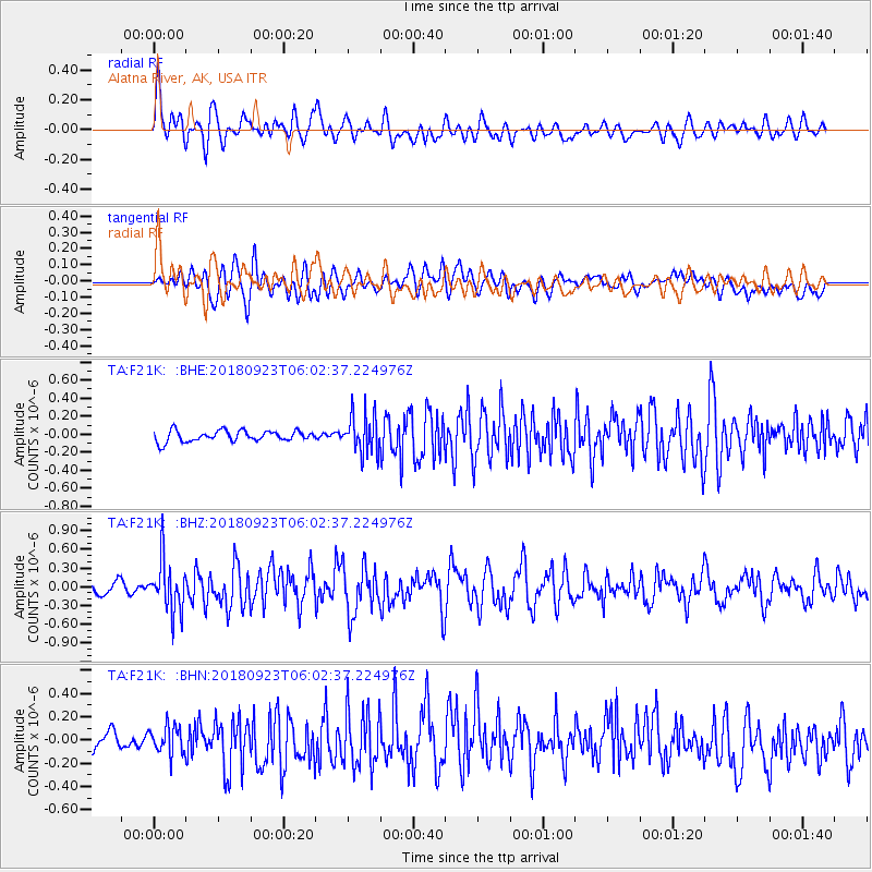
Signal To Noise
| Channel | StoN | STA | LTA |
| TA:F21K: :BHZ:20180923T06:02:37.224976Z | 4.0490756 | 4.0474023E-7 | 9.995867E-8 |
| TA:F21K: :BHN:20180923T06:02:37.224976Z | 1.4309106 | 1.16758436E-7 | 8.15973E-8 |
| TA:F21K: :BHE:20180923T06:02:37.224976Z | 3.2794828 | 2.002267E-7 | 6.105435E-8 |
| Arrivals |
| Ps | |
| PpPs | |
| PsPs/PpSs | |


