You are here: Home > Network List > TA - USArray Transportable Network (new EarthScope stations) Stations List
> Station F26K Sheenjek River, AK, USA > Earthquake Result Viewer
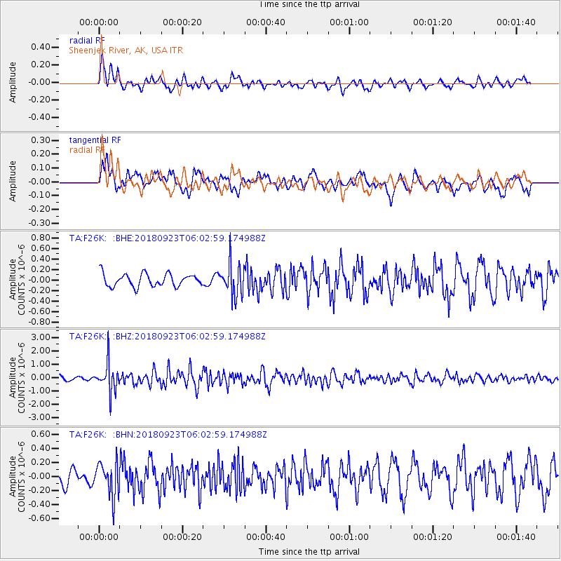
F26K Sheenjek River, AK, USA - Earthquake Result Viewer
*The percent match for this event was below the threshold and hence no stack was calculated.
| Earthquake location: |
South Of Mariana Islands |
| Earthquake latitude/longitude: |
12.2/146.2 |
| Earthquake time(UTC): |
2018/09/23 (266) 05:52:11 GMT |
| Earthquake Depth: |
10 km |
| Earthquake Magnitude: |
5.9 Mww |
| Earthquake Catalog/Contributor: |
NEIC PDE/us |
|
| Network: |
TA USArray Transportable Network (new EarthScope stations) |
| Station: |
F26K Sheenjek River, AK, USA |
| Lat/Lon: |
67.69 N/144.15 W |
| Elevation: |
683 m |
|
| Distance: |
71.1 deg |
| Az: |
22.226 deg |
| Baz: |
255.643 deg |
| Ray Param: |
$rayparam |
*The percent match for this event was below the threshold and hence was not used in the summary stack. |
|
| Radial Match: |
57.893707 % |
| Radial Bump: |
400 |
| Transverse Match: |
69.36111 % |
| Transverse Bump: |
400 |
| SOD ConfigId: |
13570011 |
| Insert Time: |
2019-05-01 08:06:29.009 +0000 |
| GWidth: |
2.5 |
| Max Bumps: |
400 |
| Tol: |
0.001 |
|
Signal To Noise
| Channel | StoN | STA | LTA |
| TA:F26K: :BHZ:20180923T06:02:59.174988Z | 5.667779 | 1.1018544E-6 | 1.9440674E-7 |
| TA:F26K: :BHN:20180923T06:02:59.174988Z | 1.9159939 | 2.4907362E-7 | 1.2999709E-7 |
| TA:F26K: :BHE:20180923T06:02:59.174988Z | 2.4780796 | 3.0228892E-7 | 1.2198517E-7 |
| Arrivals |
| Ps | |
| PpPs | |
| PsPs/PpSs | |


