You are here: Home > Network List > TA - USArray Transportable Network (new EarthScope stations) Stations List
> Station G19K Purcell Mountains, AK, USA > Earthquake Result Viewer
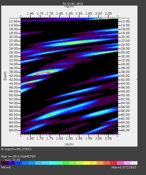
G19K Purcell Mountains, AK, USA - Earthquake Result Viewer
| Earthquake location: |
South Of Mariana Islands |
| Earthquake latitude/longitude: |
12.2/146.2 |
| Earthquake time(UTC): |
2018/09/23 (266) 05:52:11 GMT |
| Earthquake Depth: |
10 km |
| Earthquake Magnitude: |
5.9 Mww |
| Earthquake Catalog/Contributor: |
NEIC PDE/us |
|
| Network: |
TA USArray Transportable Network (new EarthScope stations) |
| Station: |
G19K Purcell Mountains, AK, USA |
| Lat/Lon: |
66.14 N/157.09 W |
| Elevation: |
391 m |
|
| Distance: |
65.8 deg |
| Az: |
21.881 deg |
| Baz: |
243.614 deg |
| Ray Param: |
0.058060247 |
| Estimated Moho Depth: |
38.5 km |
| Estimated Crust Vp/Vs: |
1.71 |
| Assumed Crust Vp: |
6.577 km/s |
| Estimated Crust Vs: |
3.84 km/s |
| Estimated Crust Poisson's Ratio: |
0.24 |
|
| Radial Match: |
85.37633 % |
| Radial Bump: |
400 |
| Transverse Match: |
64.328926 % |
| Transverse Bump: |
400 |
| SOD ConfigId: |
13570011 |
| Insert Time: |
2019-05-01 08:06:34.713 +0000 |
| GWidth: |
2.5 |
| Max Bumps: |
400 |
| Tol: |
0.001 |
|

Signal To Noise
| Channel | StoN | STA | LTA |
| TA:G19K: :BHZ:20180923T06:02:26.049988Z | 9.068556 | 1.1517833E-6 | 1.2700846E-7 |
| TA:G19K: :BHN:20180923T06:02:26.049988Z | 2.2599676 | 3.2259823E-7 | 1.4274463E-7 |
| TA:G19K: :BHE:20180923T06:02:26.049988Z | 5.248787 | 5.729473E-7 | 1.0915804E-7 |
| Arrivals |
| Ps | 4.4 SECOND |
| PpPs | 15 SECOND |
| PsPs/PpSs | 20 SECOND |


