You are here: Home > Network List > TA - USArray Transportable Network (new EarthScope stations) Stations List
> Station Y18A Canyon Day Junior High, Whiteriver, AZ, USA > Earthquake Result Viewer
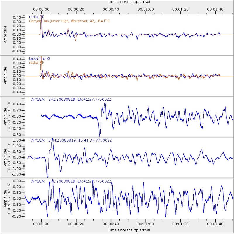
Y18A Canyon Day Junior High, Whiteriver, AZ, USA - Earthquake Result Viewer

| Earthquake location: |
Tonga Islands |
| Earthquake latitude/longitude: |
-15.1/-173.5 |
| Earthquake time(UTC): |
2008/08/19 (232) 16:30:13 GMT |
| Earthquake Depth: |
8.0 km |
| Earthquake Magnitude: |
5.6 MB, 5.9 MS, 6.1 MW, 6.0 MW |
| Earthquake Catalog/Contributor: |
WHDF/NEIC |
|
| Network: |
TA USArray Transportable Network (new EarthScope stations) |
| Station: |
Y18A Canyon Day Junior High, Whiteriver, AZ, USA |
| Lat/Lon: |
33.78 N/110.03 W |
| Elevation: |
1512 m |
|
| Distance: |
77.5 deg |
| Az: |
49.742 deg |
| Baz: |
242.258 deg |
| Ray Param: |
0.050290193 |
| Estimated Moho Depth: |
38.0 km |
| Estimated Crust Vp/Vs: |
1.62 |
| Assumed Crust Vp: |
6.276 km/s |
| Estimated Crust Vs: |
3.88 km/s |
| Estimated Crust Poisson's Ratio: |
0.19 |
|
| Radial Match: |
89.146774 % |
| Radial Bump: |
376 |
| Transverse Match: |
75.967476 % |
| Transverse Bump: |
400 |
| SOD ConfigId: |
2504 |
| Insert Time: |
2010-03-06 16:12:49.438 +0000 |
| GWidth: |
2.5 |
| Max Bumps: |
400 |
| Tol: |
0.001 |
|
Signal To Noise
| Channel | StoN | STA | LTA |
| TA:Y18A: :BHN:20080819T16:41:37.775002Z | 11.256037 | 6.7303125E-7 | 5.979292E-8 |
| TA:Y18A: :BHE:20080819T16:41:37.775002Z | 3.787075 | 1.348032E-7 | 3.5595598E-8 |
| TA:Y18A: :BHZ:20080819T16:41:37.775002Z | 6.528822 | 2.588135E-7 | 3.9641684E-8 |
| Arrivals |
| Ps | 3.9 SECOND |
| PpPs | 15 SECOND |
| PsPs/PpSs | 19 SECOND |


