You are here: Home > Network List > TA - USArray Transportable Network (new EarthScope stations) Stations List
> Station P17K Kvichak River, AK, USA > Earthquake Result Viewer
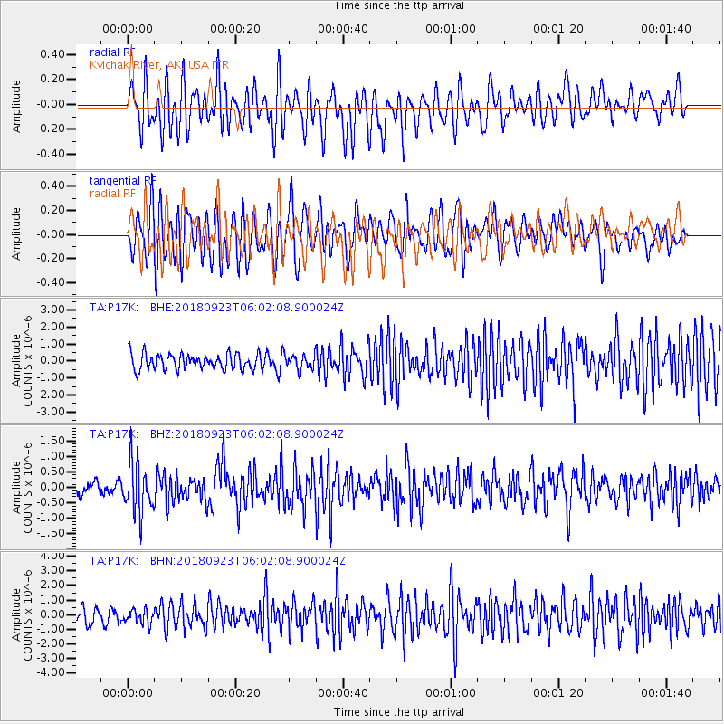
P17K Kvichak River, AK, USA - Earthquake Result Viewer
*The percent match for this event was below the threshold and hence no stack was calculated.
| Earthquake location: |
South Of Mariana Islands |
| Earthquake latitude/longitude: |
12.2/146.2 |
| Earthquake time(UTC): |
2018/09/23 (266) 05:52:11 GMT |
| Earthquake Depth: |
10 km |
| Earthquake Magnitude: |
5.9 Mww |
| Earthquake Catalog/Contributor: |
NEIC PDE/us |
|
| Network: |
TA USArray Transportable Network (new EarthScope stations) |
| Station: |
P17K Kvichak River, AK, USA |
| Lat/Lon: |
59.20 N/156.44 W |
| Elevation: |
91 m |
|
| Distance: |
63.1 deg |
| Az: |
29.051 deg |
| Baz: |
247.287 deg |
| Ray Param: |
$rayparam |
*The percent match for this event was below the threshold and hence was not used in the summary stack. |
|
| Radial Match: |
64.16484 % |
| Radial Bump: |
400 |
| Transverse Match: |
66.103485 % |
| Transverse Bump: |
400 |
| SOD ConfigId: |
13570011 |
| Insert Time: |
2019-05-01 08:07:47.406 +0000 |
| GWidth: |
2.5 |
| Max Bumps: |
400 |
| Tol: |
0.001 |
|
Signal To Noise
| Channel | StoN | STA | LTA |
| TA:P17K: :BHZ:20180923T06:02:08.900024Z | 3.3087513 | 7.999808E-7 | 2.4177726E-7 |
| TA:P17K: :BHN:20180923T06:02:08.900024Z | 0.93901616 | 4.8090544E-7 | 5.121376E-7 |
| TA:P17K: :BHE:20180923T06:02:08.900024Z | 0.99168664 | 4.4376904E-7 | 4.4748919E-7 |
| Arrivals |
| Ps | |
| PpPs | |
| PsPs/PpSs | |


