You are here: Home > Network List > TA - USArray Transportable Network (new EarthScope stations) Stations List
> Station R31K City Hall, Gustavus, AK, USA > Earthquake Result Viewer
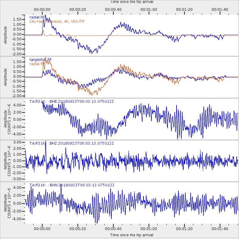
R31K City Hall, Gustavus, AK, USA - Earthquake Result Viewer
*The percent match for this event was below the threshold and hence no stack was calculated.
| Earthquake location: |
South Of Mariana Islands |
| Earthquake latitude/longitude: |
12.2/146.2 |
| Earthquake time(UTC): |
2018/09/23 (266) 05:52:11 GMT |
| Earthquake Depth: |
10 km |
| Earthquake Magnitude: |
5.9 Mww |
| Earthquake Catalog/Contributor: |
NEIC PDE/us |
|
| Network: |
TA USArray Transportable Network (new EarthScope stations) |
| Station: |
R31K City Hall, Gustavus, AK, USA |
| Lat/Lon: |
58.41 N/135.74 W |
| Elevation: |
15 m |
|
| Distance: |
73.4 deg |
| Az: |
32.497 deg |
| Baz: |
266.295 deg |
| Ray Param: |
$rayparam |
*The percent match for this event was below the threshold and hence was not used in the summary stack. |
|
| Radial Match: |
36.030205 % |
| Radial Bump: |
400 |
| Transverse Match: |
38.07634 % |
| Transverse Bump: |
400 |
| SOD ConfigId: |
13570011 |
| Insert Time: |
2019-05-01 08:08:01.056 +0000 |
| GWidth: |
2.5 |
| Max Bumps: |
400 |
| Tol: |
0.001 |
|
Signal To Noise
| Channel | StoN | STA | LTA |
| TA:R31K: :BHZ:20180923T06:03:13.075012Z | 1.9253075 | 1.002471E-6 | 5.2068094E-7 |
| TA:R31K: :BHN:20180923T06:03:13.075012Z | 1.4740063 | 1.9740785E-6 | 1.3392606E-6 |
| TA:R31K: :BHE:20180923T06:03:13.075012Z | 1.416657 | 3.3639774E-6 | 2.3745883E-6 |
| Arrivals |
| Ps | |
| PpPs | |
| PsPs/PpSs | |


