You are here: Home > Network List > TD - TransAlta Monitoring Network Stations List
> Station TD009 Z > Earthquake Result Viewer
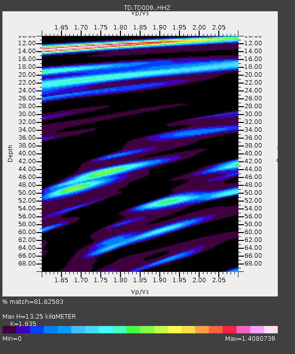
TD009 Z - Earthquake Result Viewer
| Earthquake location: |
South Of Mariana Islands |
| Earthquake latitude/longitude: |
12.2/146.2 |
| Earthquake time(UTC): |
2018/09/23 (266) 05:52:11 GMT |
| Earthquake Depth: |
10 km |
| Earthquake Magnitude: |
5.9 Mww |
| Earthquake Catalog/Contributor: |
NEIC PDE/us |
|
| Network: |
TD TransAlta Monitoring Network |
| Station: |
TD009 Z |
| Lat/Lon: |
52.32 N/116.32 W |
| Elevation: |
1335 m |
|
| Distance: |
84.9 deg |
| Az: |
37.665 deg |
| Baz: |
283.285 deg |
| Ray Param: |
0.045128223 |
| Estimated Moho Depth: |
13.25 km |
| Estimated Crust Vp/Vs: |
1.63 |
| Assumed Crust Vp: |
6.142 km/s |
| Estimated Crust Vs: |
3.757 km/s |
| Estimated Crust Poisson's Ratio: |
0.20 |
|
| Radial Match: |
81.62583 % |
| Radial Bump: |
400 |
| Transverse Match: |
62.05187 % |
| Transverse Bump: |
400 |
| SOD ConfigId: |
13570011 |
| Insert Time: |
2019-05-01 08:08:22.169 +0000 |
| GWidth: |
2.5 |
| Max Bumps: |
400 |
| Tol: |
0.001 |
|

Signal To Noise
| Channel | StoN | STA | LTA |
| TD:TD009: :HHZ:20180923T06:04:15.780029Z | 4.2821155 | 1.7581671E-6 | 4.1058374E-7 |
| TD:TD009: :HH1:20180923T06:04:15.780029Z | 1.1018112 | 2.737005E-7 | 2.4840963E-7 |
| TD:TD009: :HH2:20180923T06:04:15.780029Z | 3.5840077 | 8.289284E-7 | 2.3128533E-7 |
| Arrivals |
| Ps | 1.4 SECOND |
| PpPs | 5.5 SECOND |
| PsPs/PpSs | 7.0 SECOND |


