You are here: Home > Network List > TA - USArray Transportable Network (new EarthScope stations) Stations List
> Station Y18A Canyon Day Junior High, Whiteriver, AZ, USA > Earthquake Result Viewer
Y18A Canyon Day Junior High, Whiteriver, AZ, USA - Earthquake Result Viewer
| Earthquake location: |
Near West Coast Of Colombia |
| Earthquake latitude/longitude: |
3.0/-78.0 |
| Earthquake time(UTC): |
2007/09/10 (253) 01:49:14 GMT |
| Earthquake Depth: |
31 km |
| Earthquake Magnitude: |
6.1 MB, 6.7 MS, 6.8 MW |
| Earthquake Catalog/Contributor: |
WHDF/NEIC |
|
| Network: |
TA USArray Transportable Network (new EarthScope stations) |
| Station: |
Y18A Canyon Day Junior High, Whiteriver, AZ, USA |
| Lat/Lon: |
33.78 N/110.03 W |
| Elevation: |
1512 m |
|
| Distance: |
42.8 deg |
| Az: |
319.413 deg |
| Baz: |
128.734 deg |
| Ray Param: |
0.07288519 |
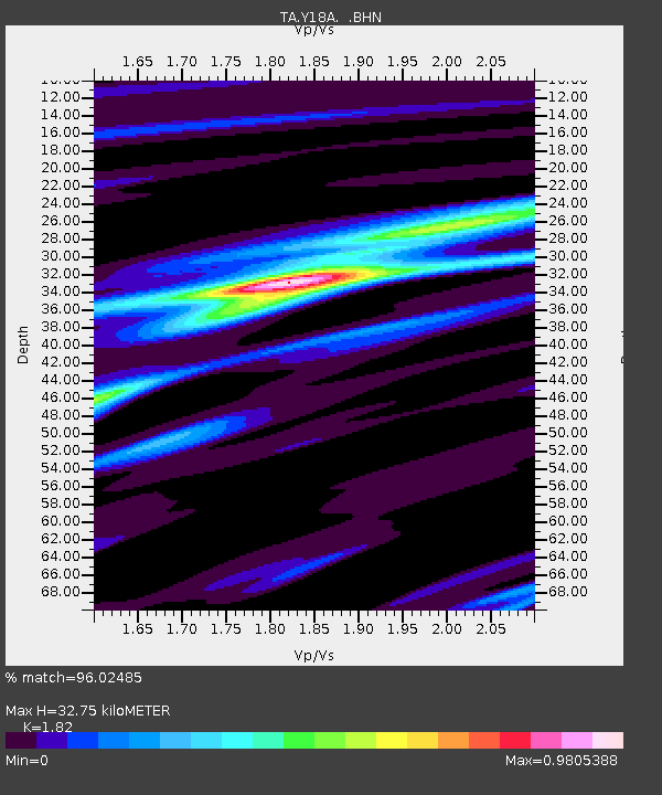
| Estimated Moho Depth: |
32.75 km |
| Estimated Crust Vp/Vs: |
1.82 |
| Assumed Crust Vp: |
6.276 km/s |
| Estimated Crust Vs: |
3.448 km/s |
| Estimated Crust Poisson's Ratio: |
0.28 |
|
| Radial Match: |
96.02485 % |
| Radial Bump: |
306 |
| Transverse Match: |
80.67428 % |
| Transverse Bump: |
400 |
| SOD ConfigId: |
2564 |
| Insert Time: |
2010-03-06 16:13:42.375 +0000 |
| GWidth: |
2.5 |
| Max Bumps: |
400 |
| Tol: |
0.001 |
|
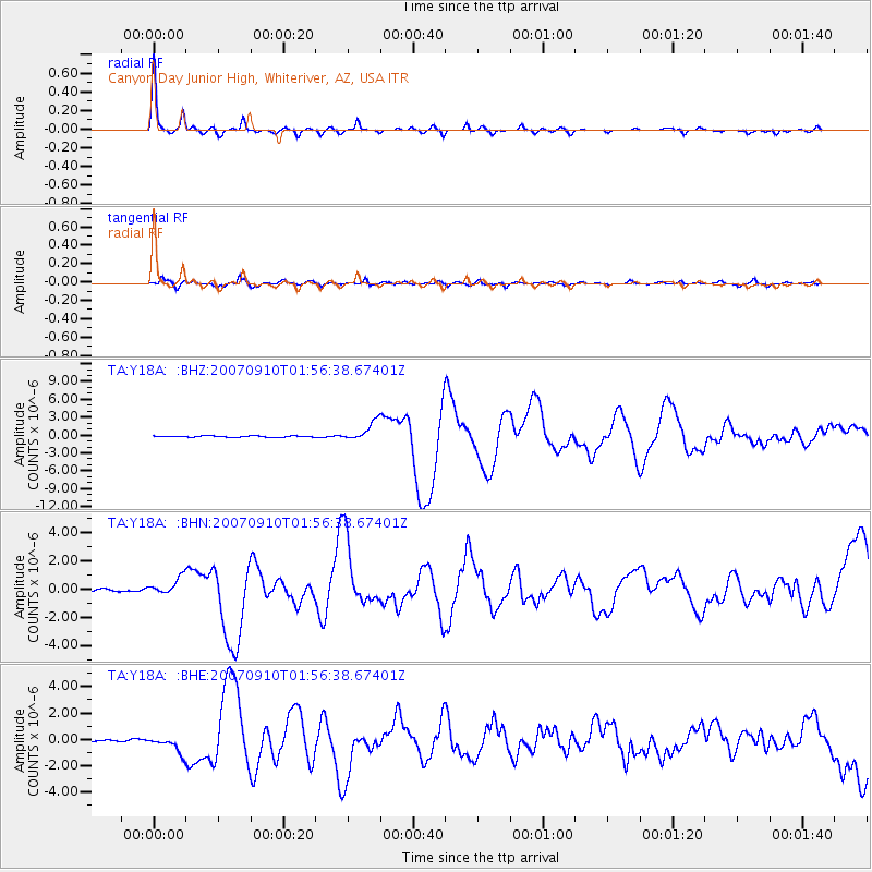
Signal To Noise
| Channel | StoN | STA | LTA |
| TA:Y18A: :BHN:20070910T01:56:38.67401Z | 4.6056013 | 5.923103E-7 | 1.286065E-7 |
| TA:Y18A: :BHE:20070910T01:56:38.67401Z | 6.320529 | 6.0827983E-7 | 9.623875E-8 |
| TA:Y18A: :BHZ:20070910T01:56:38.67401Z | 14.3510895 | 1.6028835E-6 | 1.1169072E-7 |
| Arrivals |
| Ps | 4.6 SECOND |
| PpPs | 14 SECOND |
| PsPs/PpSs | 18 SECOND |


