You are here: Home > Network List > UW - Pacific Northwest Regional Seismic Network Stations List
> Station UMAT Pilot Rock, OR, USA > Earthquake Result Viewer
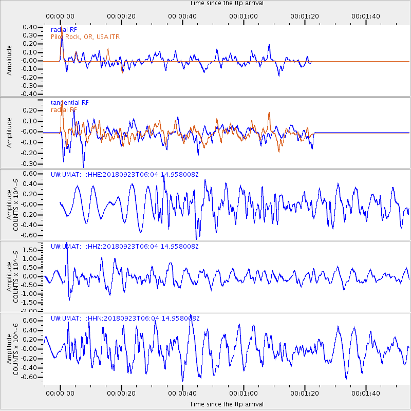
UMAT Pilot Rock, OR, USA - Earthquake Result Viewer
*The percent match for this event was below the threshold and hence no stack was calculated.
| Earthquake location: |
South Of Mariana Islands |
| Earthquake latitude/longitude: |
12.2/146.2 |
| Earthquake time(UTC): |
2018/09/23 (266) 05:52:11 GMT |
| Earthquake Depth: |
10 km |
| Earthquake Magnitude: |
5.9 Mww |
| Earthquake Catalog/Contributor: |
NEIC PDE/us |
|
| Network: |
UW Pacific Northwest Regional Seismic Network |
| Station: |
UMAT Pilot Rock, OR, USA |
| Lat/Lon: |
45.29 N/118.96 W |
| Elevation: |
1318 m |
|
| Distance: |
84.8 deg |
| Az: |
44.94 deg |
| Baz: |
281.958 deg |
| Ray Param: |
$rayparam |
*The percent match for this event was below the threshold and hence was not used in the summary stack. |
|
| Radial Match: |
68.14875 % |
| Radial Bump: |
400 |
| Transverse Match: |
79.84581 % |
| Transverse Bump: |
400 |
| SOD ConfigId: |
13570011 |
| Insert Time: |
2019-05-01 08:09:32.054 +0000 |
| GWidth: |
2.5 |
| Max Bumps: |
400 |
| Tol: |
0.001 |
|
Signal To Noise
| Channel | StoN | STA | LTA |
| UW:UMAT: :HHZ:20180923T06:04:14.958008Z | 6.0201273 | 7.401288E-7 | 1.229424E-7 |
| UW:UMAT: :HHN:20180923T06:04:14.958008Z | 0.9124042 | 1.820809E-7 | 1.9956167E-7 |
| UW:UMAT: :HHE:20180923T06:04:14.958008Z | 1.3108044 | 2.7032962E-7 | 2.0623185E-7 |
| Arrivals |
| Ps | |
| PpPs | |
| PsPs/PpSs | |


