You are here: Home > Network List > TA - USArray Transportable Network (new EarthScope stations) Stations List
> Station Y18A Canyon Day Junior High, Whiteriver, AZ, USA > Earthquake Result Viewer
Y18A Canyon Day Junior High, Whiteriver, AZ, USA - Earthquake Result Viewer

| Earthquake location: |
Sakhalin, Russia |
| Earthquake latitude/longitude: |
47.1/141.8 |
| Earthquake time(UTC): |
2007/08/02 (214) 02:37:42 GMT |
| Earthquake Depth: |
5.0 km |
| Earthquake Magnitude: |
6.2 MS, 5.3 MB, 6.2 MW, 6.2 MW |
| Earthquake Catalog/Contributor: |
WHDF/NEIC |
|
| Network: |
TA USArray Transportable Network (new EarthScope stations) |
| Station: |
Y18A Canyon Day Junior High, Whiteriver, AZ, USA |
| Lat/Lon: |
33.78 N/110.03 W |
| Elevation: |
1512 m |
|
| Distance: |
76.9 deg |
| Az: |
54.349 deg |
| Baz: |
318.219 deg |
| Ray Param: |
0.05070118 |
| Estimated Moho Depth: |
36.75 km |
| Estimated Crust Vp/Vs: |
1.75 |
| Assumed Crust Vp: |
6.276 km/s |
| Estimated Crust Vs: |
3.581 km/s |
| Estimated Crust Poisson's Ratio: |
0.26 |
|
| Radial Match: |
84.516945 % |
| Radial Bump: |
400 |
| Transverse Match: |
66.409904 % |
| Transverse Bump: |
400 |
| SOD ConfigId: |
2564 |
| Insert Time: |
2010-03-06 16:13:57.097 +0000 |
| GWidth: |
2.5 |
| Max Bumps: |
400 |
| Tol: |
0.001 |
|
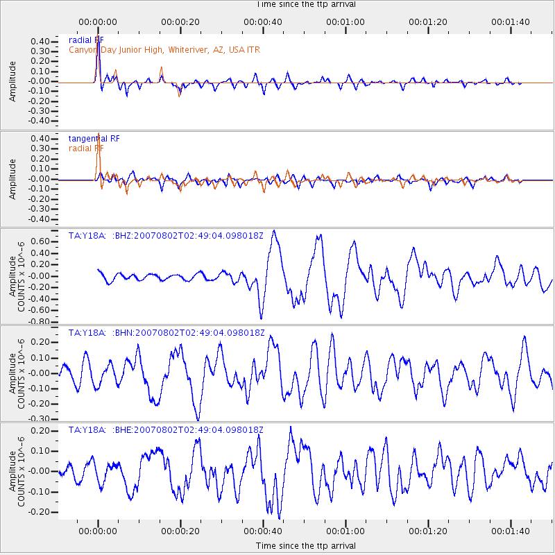
Signal To Noise
| Channel | StoN | STA | LTA |
| TA:Y18A: :BHN:20070802T02:49:04.098018Z | 1.5640104 | 6.273553E-8 | 4.0111967E-8 |
| TA:Y18A: :BHE:20070802T02:49:04.098018Z | 1.0804418 | 4.5042544E-8 | 4.1689002E-8 |
| TA:Y18A: :BHZ:20070802T02:49:04.098018Z | 1.3827671 | 7.649583E-8 | 5.5320832E-8 |
| Arrivals |
| Ps | 4.5 SECOND |
| PpPs | 16 SECOND |
| PsPs/PpSs | 20 SECOND |


